 I was a little nervous about hiking Kaaterskill, since it was the first of the 3500 that wasn't entirely an official trail that I was doing alone. It's not a true bushwhack, but there was always the potential I wouldn't be able to find my way.
I chose to approach from the shorter route, Plattekill Clove in the south. The beginning of the hike is on a true trail, part of the Long Path and also a snowmobile trail. Officially, there is a juncture that takes you south to another snowmobile loop, and from there an unofficial trail heads across the summit and down the other side, reconnecting with the snowmobile loop.
However, being lazy, I decided to take the shortcut trail that has been made to the inner loop, and from there proceed north to the summit. (I'm not actually sure that it's shorter, though.) I was worried I wouldn't see the shortcut, but it was hard to miss. It was mostly easy to follow, aside from one confusing spot, but then it popped right out onto the inner loop. I followed it counterclockwise, again worrying I wouldn't see the unofficial trail to the peak, but again it was obvious. The trail itself does actually have blue blazes.
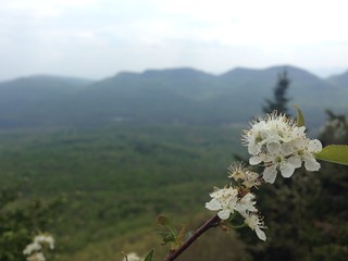 The trail up the peak is steep and requires scrambling, near-vertical in spots. It takes you up to Hurricane Ledge. If I remember right (and I hope I don't), someone said there wasn't much of a view from here, and that's not the case at all! You can see Twin, Sugarloaf, and Indian Head across the valley.
From Hurricane Ledge to the summit is a more reasonable walk rather than a scramble. There is no canister, but I found a geodetic marker. I gave a brief thought to crossing the peak and coming back the proper way; that thought died when I couldn't find the trail, just one to another ledge. I went back the same way I came.
Do this hike on a day with views, and when it's dry - you would not want to scramble up the rocks when they're wet. If I were to do it again, I'd loop around to the north properly, and also perhaps hike out to Huckleberry Point. My time was limited, though, due to an afternoon start.
No comments:
Post a Comment