Thursday, March 23, 2017

Circumnavigating Lake Minnewaska

Lake Minnewaska

After not making it to the top of SW Hunter, J and I decided that we likely wouldn't be able to make it to the top the next day ... or to the top of any other Catskill peak. Luckily, the 3500 isn't the only list we are working on. There is the Views and Brews patch, for one.

We had to head south to return our rental car anyway, so we decided to do something in the New Paltz area. I've driven through the Shawangunks and even stayed in New Paltz, but never hiked there. The Gunks are most famous as a climbing area; that doesn't mean they don't have nice hiking.

Minnewaska State Park Preserve (entrance fee required) was perfect for a nice snowshoe hike. The trail around the lake is just a few miles. It has some elevation gain and loss, but nothing like the Catskills. And the snowshoeing conditions were perfect - especially since trail was already broken. It was the introduction to snowshoeing I should have given to J!

Cross-country skiers and even booted hikers were also out, although the latter had some tougher work cut out for them. We found the snowshoeing easy as we hiked counterclockwise around the lake, which came in and out of view.

Afterwards, we had to fulfill the "brews" part of the requirement. We stopped at Rough Cut Brewing, which had really excellent beer (I only sipped tiny tastes of J's flight, being the driver, but the nachos were also quite good).

All told, the hike is two picturesque miles, with the ability to add miles via other trails.

Lake Minnewaska

Monday, March 20, 2017

Hiking to Diamond Notch again

Diamond NotchSince I have one peak left in my Catskills 3500, J and I headed up to the Catskills this past weekend in spite of the major snowstorm earlier in the week. It was heavy enough that some cities and counties simply shut down all their roads the next day while they dug out. By Friday, the roads were perfectly clear, and the forecast only called for a light snow on Saturday.

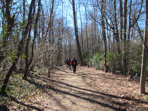
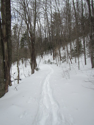
There are several different routes up SW Hunter, my remaining peak, but coming up from Diamond Notch is supposedly the easiest. We had hiked that route as far as the falls back in January and knew that part of it was flat to gently sloping. Of course, things are different under a couple of feet of fresh powder.

Someone had clearly been through in skis a day or two earlier, but the trail was essentially unbroken. Since it was J's first time on snowshoes, I was breaking trail. But with only one set of prints, J was doing a fair bit of work, too.

Once we reached the falls, it was evident the trail ahead was totally unbroken (and about to get steeper). We decided to turn back. We learned later that a couple of folks came through that afternoon and broke trail for another mile and a half, turning around when the snow swallowed up their legs - so we made a good choice.

Upon turning around, snowshoeing in our own trail was easier ... at least until we reached the point where a small group had postholed to, mucking up the trail.

It probably wasn't the best first snowshoe experience for J, but I had expected that someone would have broken trail before us. Even if we went back the next day, we would have had to go at least a mile in deep, unbroken powder, and it sounded like too much.

So SW Hunter still remains, and I won't get back up there anytime in the immediate future.

Wednesday, March 8, 2017

New Rochelle-Larchmont

New Rochelle-Larchmont

For some reason, I thought this hike was going to be less suburban. Okay, I knew it was in the suburbs, but I thought we'd see more parks and fewer houses. Instead, the first 2/3 was a mix of small shoreline parks and expensive homes, and the final 1/3 was on a strip of land that had somehow been preserved in suburbia.

We had a day that was sunny despite the cold - and it was cold. Early on, we did some in-and-out walks into parks.

New Rochelle-Larchmont

After that, we wove in and out of expensive homes and waterfront parks.

New Rochelle-Larchmont

The end of the 12-mile hike was on the Leatherstocking Trail.

New Rochelle-Larchmont

I can't say there was anything spectacular about the hike; if you live in the area, it would be a natural place to go. As a destination, it's a change of pace, but not the kind of hiking one falls in love with.

Friday, March 3, 2017

Hiking from Massapequa to Cold Spring Harbor

Massapequa-Cold Spring Harbor

Even as I planned to go on the Ramblers hike on Sunday, I had little idea of what to expect. Yes, I had looked at Google Maps, seeing that it was a 14-mile drive between the two train stations. Yes, I know Long Island is mostly flat. But I didn't see much in the way of green space on that map, so I was worried it would be a lot of suburbia.

My fears were unfounded, in the end. We went near a lot of suburbia, but not through it. Turns out there is a thin green corridor running nearly the whole way. Much of this is Trail View State Park, land that was bought for a highway that was never built.

It is true that at the very end, we had to walk about a mile alongside the road, and along the way we had some road crossings: This was by no means the wilderness.

Still, most of the trail was surrounded by trees ("green space" being an not entirely accurate term this time of year). It was almost entirely flat, aside from a few small hills at the end. We totted up 17 miles, although part of the group took a longer detour at the end.

One quick note: We had an exhaustively detailed hike description from a hiking book, but there are a lot of trails that criss-cross each other and aren't always well-marked. This isn't so much true where the trail is in a thin corridor, but where it passes through parks it isn't easy to follow. Be warned.

Thursday, March 2, 2017

Staten Island amble

Staten Island
J and I took a visit to Staten Island and took a stroll along the waterfront. From the ferry, we walked west as far as Snug Harbor and then back, about two flat miles each way.

Much of waterfront is hidden, either by businesses, such as the Atlantic Salt Company, or by construction. The waterfront that is accessible isn't exactly developed. J reminisced about when Brooklyn's waterfront was the same way, back in the day.

This view was taken from the shore across from Snug Harbor looking east. The photo below is from the same spot, but looking west. The remains of the old railroad, I found out later, are what is left of a railway route that used to run from the ferry to about Goethels Bridge, crossing over into New Jersey on the Arthur Kill Railroad Bridge. The rail stopped running in 1990.

Staten Island