Tuesday, December 31, 2019

Walking in Lebanon

I was wondering if I could take any interesting walks while at home, and I found the Build Lebanon Trails website, which describes current and future greenways. During my visit, the fam did two of the most scenic local walks.
Mark Slough

The first of these was Marks Slough, starting at Had Irvine Park. It's just over two miles of paved, flat trail. Mostly, it's pretty, but there are some spectacular views as it passes by the Santiam River.

Cheadle Lake

The second was a walk on the North Shore and Island Loop Trails by Cheadle Lake. Again, it was flat, although sections were unpaved, as we walked a bit over 3 miles. If one covered every bit, it would be more like 4.

The lake is supposed to be good for bird watching, and we saw geese, ducks, a heron, and an egret. Also, of course, the lake was pretty, and the North Shore trail was on a narrow strip of land between the lake and the canal.

Many of the other trail sections that we skipped are shorter, or cross more streets. You could piece together a much longer walk if you wished.

2019 in photos

January:
New year's day hike

February:
Camp Nawakwa

March:
Black Dome and Thomas Cole

April:
RD end-to-end

May:
Westchester hike

June:
Netherlands

July:
Luxembourgh

August:
Harriman

September:
McKenzie

October:
Impeach

November:
Batona Trail

December:
 The Six

Sunday, December 22, 2019

Hiking "The Six" in winter

A hiking buddy convinced me to do The Six in winter, despite thinking it was more than enough in summer, when there is plenty of daylight. So off we went.

The Six

First, we headed up Friday, which is a long, slow hike. M, our hike leader, set a nice slow pace that would be easy to keep all day. But once you get up Friday, you've gained the biggest portion of your elevation for the day.

The Six

Just past the summit you'll find the above view. From there we proceeded to Balsam Cap. Even though the first four peaks are not on trails, we were helped by following a recent set of snowshoe tracks. I will say that the snow, while it takes effort, does reduce the number of trip hazards as compared to the summer.

Lone

After Balsam Cap, my only photos are of the summits - it was getting colder and my camera was hard to get to. The photo above is of the last off-trail peak, Lone, which you can see we reached in the dark. From there we got onto the trail to Table and Peekamoose.

(This makes the latter two the Catskills peaks I have climbed the most times, at four each. Er, and also Slide, I've also done that four times.)

We didn't get back to the cars until about 11:20, so it was a very long day. And now I really don't have to do The Six again!

Sunday, December 15, 2019

Following the Hudson Greenway

I have a major hike next weekend, so I wanted to do some elevation today. However, I had a party last night, and even though I didn't overdo it (except in the sense of eating too many cookies), I did need to sleep in. So, rather than taking a bus or train somewhere, I just set out from my house, heading north through Riverside Park.

Manhattan walk

I decided to take as many opportunities as possible to gain or lose elevation. It wouldn't be Everest no matter what, but there are plenty of stairs and more modest slopes in in Riverside Park. I made it to (and around) Inwood Park at the northern tip of the island, for a total of 12 miles and 1,200 feet of elevation gain. That's pretty decent for Manhattan. (You could certainly do more by, say, running up and down a staircase, but for a coherent and non-repetitive walk, it's good.)

Manhattan walk

An unexpected benefit was encountering places I hadn't seen in a while, or ever, even though I've been on this general route many times. (See both of the above photos for examples.) Of course I also saw old favorites such as the Little Red Lighthouse, but it's always nice to find new corners of old places.

Monday, December 2, 2019

Thru-hiking the Batona Trail

Five years ago, I tried to hike the Batona Trail over Thanksgiving but gave up after one night because my gear just wasn't sufficient for cold weather. Now, with better gear and a friend in tow, I tried again.

Batona Trail

There were several things that helped me this time:

  1. Better gear. Most importantly, a better sleeping pad. 
  2. Improved trail signs. We only wandered off course when we weren't paying attention.
  3. The new Southern Ocean County Park and Ride, which allows for a much earlier hiking start on day 1 when coming from NYC.
We took a bus from Port Authority to the SOCPaR Wednesday morning, then a taxi to the southern trailhead. The first day was a longish one - and on top of the Batona trail itself, there was slightly more than a mile on the spur trail to the first campsite, Buttonwood Hill Camp. The third day is also long, with days two and four being short (if you stay at Lower Forge and Brendan T. Byrne.)

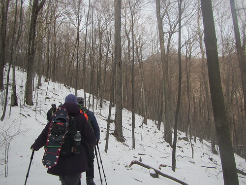
It was sunnier on day two, albeit windy. (Our trip had been predicated on the weather being decent; of course it would be cold, but we had agreed to cancel if it was rainy or nasty. We lucked out here.)

Batona Trail

Lower Forge Camp is slightly closer to the main trail than the first camp. One could push on to Batona Camp, but then day three becomes long instead; it's a toss-up. I wouldn't do the entire hike in less than four days in the winter, personally, because of limited daylight. Three could be reasonable in summer.

Batona Trail

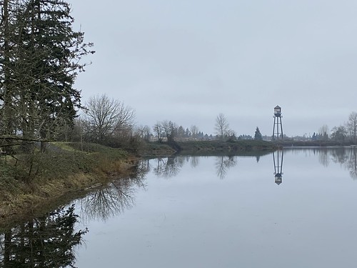
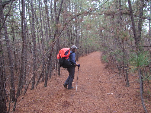
On day three, we saw Apple Pie Hill and its fire tower, as well as some nice lakes. Access to the fire tower is limited to when it is staffed, so we expected to be shut out, but to our surprise it was open. This is the view. You can see how flat the landscape is!

Batona Trail

We found the Franklin Parker "reroute" (it's been there since 2012 but still isn't on the official map!) confusing. Not confusing to follow, because of the good signage, but we just couldn't match up what we saw with what was indicated on the map. The map shows you walking by one lake, but we passed three. Very pretty, to be sure, but perplexing.

Batona Trail

The third night at Brendan T. Byrne was the coldest, and also the only night we didn't have the entire campground to ourselves.

Batona Trail

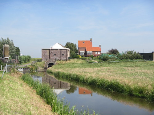
The above photo of Pakim Pond, which we passed on the last day, is a little misleading. The pond is probably very pretty at times! But the water level was low, making the shore rather unattractive. We also climbed our second fire tower, Lebanon, which is unstaffed but open.

From there we pushed a little fast, since we had an appointment with a Lyft at the northern trailhead. But we made it to mile 52.7 with about ten minutes to spare. Our Lyft took us to the Tom's River Park and Ride, and from there we caught a completely full bus back to the city.

It was a nice hike! If you want to do the same route, we used this trail guide, which was very helpful, and the guidance of the Facebook group dedicated to the trail.

Tuesday, November 12, 2019

Hiking the Timp-Torne trail

Sunday's club hike was rather strenuous - not so much the terrain, but the speed. Due to a variety of circumstances, we ended up hiking much faster than usual (and, in fact, finishing an hour ahead of schedule).

Timp-Torne Trail

We followed the Timp-Torne Trail through Bear Mountain State Park, although I and a few others elected to skip Popolopen Torne (since I was just there recently) and to go around Brooks Lake.

The hike has plenty of nice views anyway, but they're even better with the leaves off. The photo below is of Bear Mountain; if you look closely, you can see the tower on top.

Timp-Torne Trail

My total distance was 12.5 miles; elevation is unknown because I still haven't figured out how to work my new altimeter.

Timp-Torne Trail

A loop in VCP

Van Cortlandt Park

This month's Van Cortlandt trailwork involved hiking - we hiked a three-mile loop for survey purposes, noting different aspects of the trail as we went along. Nice work if you can get it!

Monday, October 28, 2019

Hiking to Popolopen Torne

Popolopen Torne is a nice alternative to the crowds at Bear Mountain, particularly on a nice fall day when half the city descends upon the park. It may not be as easy as I had told my friend D (a somewhat regular hiker) and his friends (not hikers), though.

Popolopen Torne

From the Bear Mountain Inn, you hike past the lake and get to the tricky part of the hike. In their infinite wisdom, the trail designers started the Popolopen Gorge trail right by the side of the road - not near any place to park - requiring hikers to cross over some busy highways. The only reason this is doable is that the highways are all converging on a traffic circle here.

Popolopen Torne

The trail itself roughly follows a creek. I had described it to my hiking companions as "mostly flat," but that turned out to be not as true as I remembered. (Plus, "flat" to a non-hiker is flatter than to me.) But it's a very pretty trail with views of the water and the Torne.

Popolopen Torne

After crossing the creek, the trail starts to gain elevation. You have two potential routes up that, put together, make a nice loop. We opted to take the western side of the loop both up and down, however. Either way, the hill turns into a scramble.

Popolopen Torne

At the top, there are great views of the Bear Mountain Bridge over the Hudson and Anthony's Nose behind it. There is also a West Point soldier's memorial.

Popolopen Torne

We retraced our route, getting to the Inn about ten minutes before the bus was to arrive. When it did, there were too many passengers and a second bus had to be called, which arrive about 90 minutes later. This part was not delightful.

However, it was a beautiful fall day with great views!

Sunday, October 20, 2019

North Staten Island

Staten Island

It was one of those days where none of my plans worked out thanks to the MTA, so I ended up just hiking on the north shore of Staten Island, a very flat 5.6 miles. It's all sidewalks, ranging from very scenic to very much not. Also, sadly, much of it absolutely fails to be ADA-accessible, thanks to overgrown and crumbling sidewalks (and random mid-block street side changes). Here are a couple of the more scenic images.

Staten Island

Monday, October 7, 2019

Hiking for animals in Harriman

On Sunday, I led a hike in Harriman State Park - the fauna hike. A friend and I had come up with a list of silly theme hikes in Harriman, of which this was one. The idea was to explore as many features with animal names as possible.

It turns out that the majority of animal names are in the southern part of the park, and we visited most of them. We started at the Pomona Heights entrance on the eastern side, and made our way over to Sloatsburg on the western side, hiking 15 miles in the process.

Harriman Fauna Hike

Despite the theme, I couldn't guarantee any actual animal sightings, aside from perhaps chipmunks and squirrels. Nevertheless, the trail provided. While at the head of the group on Conklins Crossing Trail, I nearly tripped across a rattling rattlesnake - thankfully, another hiker warned me. Eventually, the very fat snake slithered off. We came across a very long garter snake not much later, but much more safely.

Harriman Fauna Hike

We were blessed with cool weather - although some sun would have been nice, I can't complain. I'm ready for the summer heat to be behind us.

The hike had surprisingly varied terrain and views given that it was planned based on names, not sights.

Saturday, October 5, 2019

Hiking South Mountain Reservation

I've been to South Mountain a few times before - it's a surprising oasis in the middle of New Jersey. On this hike with a friend, we saw Hemlock Falls, but went to it via a different route. Here's a small cataract on the way.

South Mountain

Wednesday, October 2, 2019

Exploring City Island

I'm (slowly) visiting all the islands of New York City - or, at least, the ones that have bridges, ferry service, or other regular transit to them. I'm not going to kayak to all the little ones. So, I cooked up the idea of leading a hike to City Island and Pelham Bay Park. It would at least give me an excuse to scout it.

I started from the Pelham Bay subway stop. Now, I've visited Pelham Bay Park twice before. For this hike, it was more of a place to walk through than a place to explore. Below is a view from the bridge from Pelham Bay to City Island.

City Island

City Island itself is small, and it has a lot of restaurants, especially seafood restaurants.

City Island

While it was interesting once, I didn't think it would make a great Ramblers hike, so I've put that idea on the back burner.

Sunday, September 29, 2019

A scouting hike in Harriman

Last weekend I headed up to Harriman to scout a hike I'm leading in October - my third try. Thankfully, I made it this time, even if the weather had returned to being unpleasantly hot.

Harriman

The hike enters Harriman from an entrance I don't think I've used before. It's a much gentler entrance than most of them, which head straight uphill. As you can see above, it's a hill, just more modest.

My hike was slower than the actual hike is likely to be, mostly because I had to do some route-finding when it came to old roads. So I explored more side trails, which took extra time.

Harriman

Unfortunately, in the afternoon I missed a turn off a road back onto a trail, and found myself at Pine Meadow Lake. It's very pretty, but not where I was supposed to be. I didn't feel like retracing my steps, though, instead opting to take an easy way out.

Harriman

Well, mostly easy. It was pretty flat, but part of it was on a bouldery trail following a creek.

Harriman

The downside of this hike is that there is a two-mile roadwalk at the end. It's not particularly interesting, and I wouldn't love doing it in the dark. Here's hoping the official hike doesn't have to!

Saturday, September 21, 2019

Hiking Hadley Mountain

Hadley Mountain
My final hike was chosen strategically; I wanted to do a fire tower on the southern end of the Adirondacks, so it would break up the drive home. Hadley and Spruce were the top two choices, and I chose Hadley as it was slightly harder.

The first mile of trail looks just like the photo at left - as if the trail is paved. It's not, of course; it's just bare granite. It makes for good footing, as there is almost no scrambling. But it's also quite steep, with a good chunk of the 1525 feet of elevation gained in this portion. The trail then abruptly levels off, and the rest of the .8 miles intersperses flat areas and modest hills.

There are a couple of viewpoints near the top:

Hadley Mountain

I climbed the tower, although the cab was closed, and as promised there were 360-degree views. Despite the trail being busy, I had the rare good luck of having the summit to myself.

Hadley Mountain

Afterwards, I got back in the car and headed home.

Friday, September 20, 2019

Moriah Challenge: Big Hollow/Coot Hill

On Friday, I had tried to get to the trailhead for this hike and had given up. It was my fault for being lazy about gathering intel: I knew one turned on Lang Road and went "a ways" down to park, or went "a ways" further and parked at the actual trailhead. I hadn't bothered to figure what those distances actually were, and the trail isn't on the National Geographic maps. Plus, I had no cell signal.

I turned onto the gravel road and went past the houses. The last few had signs like "don't park here, park down the road." The gravel road was hilly but fine, until I got to a short, steep section with some washboard. Not knowing if it would get worse, I turned my fragile little rental car around.

On Sunday morning, I went back with better info. The trailhead was two miles down, folks said, and the road wasn't that bad.

Nevertheless, I stopped at the same hill again. It was about .7 from the trailhead, and there was a parking area just before the hill. (That is, it didn't say it was a parking area, but it also didn't say it wasn't or to keep out.) With the hike being a mile one-way, an additional .7 wouldn't be an issue.

Of course, that one hill turned out to be the only questionable part of the road! Oh well - I reached the cemetery, the real start of the hike, just the same.

Coot Hill/Big Hollow

The rest of the trail is an old dirt road no longer passable by cars. There is a modest hill, then the trail ends at a magnificent view.

Coot Hill/Big Hollow

I did this hike in something of a hurry, and I didn't stay at the viewpoint too long. Bugs had been bombarding me the entire way, and I was tired of things bouncing off my head.

So this was the completion of the Moriah Challenge. None of the four hikes are very hard. Belfry offers the best views, being a fire tower, and a very short hike. Cheney and Big Hollow also have good views. Crowfoot Pond is the longest, so one could do them all in one day if one was even modestly determined to do so.