My last long hike of the year was a loop starting at the Cool Spring trailhead. 10 miles, nowhere I hadn’t been before, but I finished my goal of at least one 10-mile hike a month for the year.

My last long hike of the year was a loop starting at the Cool Spring trailhead. 10 miles, nowhere I hadn’t been before, but I finished my goal of at least one 10-mile hike a month for the year.
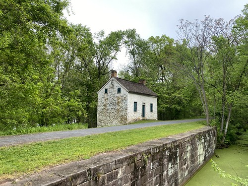
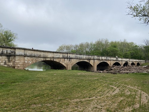
In November, I joined the Wilmington Trail Club's Hike Across Delaware, which crosses the entire width of Delaware along the Chesapeake & Delaware Canal trail. It does sound impressive to walk across an entire state in one day, but at 15 flat miles, it's the easiest state you'll ever hike across.

The event is well organized, with a bus taking hikers to the starting point in Maryland. There are plenty of restrooms along the way, snacks at mile 10, and a souvenir bandana.

This is not a hike for the heat of summer, being very open, but it is scenic. Nearly all of it hugs the surprisingly wide canal, and for most of the hike, the canal is in view.

I have now walked across two states; this was considerably easier than traversing Vermont on the Long Trail!
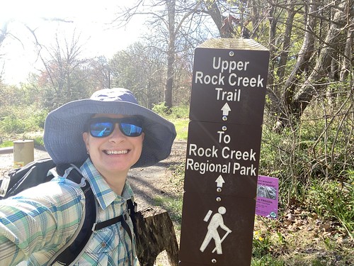
Six months after hiking the upper portion of Rock Creek, I returned to where I left off to hike the middle portion of it. From the southern end of Lake Needwood to the DC border, a paved greeenway runs vaguely parallel to the creek for a little over 14 miles.
While it starts off unpromisingly in a grass field, the trail quickly plunges into the woods. This first section, ending when it emerges from Aspen Hill park, is quite pretty and has the fewest reminders of civilization (other than, you know, it being a paved path).

It then follows somewhat close to the road for a bit, and there is a short, depressing section absolutely overtaken by kudzu. After this, it wends through a series of local parks. There are plenty of athletic fields, views of houses, playgrounds, and short woods sections.

Beach Drive pops up, and for a while the creek and then Beach Drive run alongside it. Luckily, the road is closed to vehicles on weekends, making this another very pretty section, if more heavily used.

The trail then runs into the beltway and veers east. Here, the trail is sandwiched between Beach Drive on one side (open to cars), and the creek and the freeway on the other. Since it was a beautiful fall day, this section was pretty, but it could easily be depressing in other weather.

After passing under the beltway, the trail follows the road closely before entering more small parks. This section is mostly wooded, but there are surprisingly few views of the creek here. Eventually, it dead-ends at a parking lot at the DC line and Rock Creek Park. From there, natural surface trails lead onward.

As a practical note, there are plenty of restroom stops along the way. The biggest logistical difficulty was getting a ride at the end; my Uber driver somehow couldn't find his way there, and I had to cancel and get a Lyft. Public transit is not great in the area.
I did have an exceptionally nice fall day for my hike. I would avoid it on hot summer days, since parts of it are quite open and sunny, but it would also be fine in spring or winter.
I returned to local mountain Sugarloaf on a weekday and enjoyed hiking it with fewer crowds. This time, I parked at the East View parking lot, hiked the white trail clockwise, and the then ascended and descended via the orange trail. The parking lots start halfway up the mountain, but the white trail takes you back to the base, allowing you to climb the entire thing.
The map claims the white trail is 2.2 miles, but my tracker and Footpath both put it at 3.5 - and it certainly felt like the higher number. I don't mind the higher mileage, although it is frustrating when you have to be done by a certain time.

The orange trail is the hardest of the three summit trails, with lots of big boulders to climb. It made for a nice challenge.

My longest hike for September was an out-and-back on the C&O - pretty as always, but not noteworthy for difficulty.

I started at Riley's Lock, which I had never been to before, and walked southeast five miles. Less than a mile from the start is the next parking area, where I had been before, so most of it was known territory. There is some pretty territory with "cliffs" made in building the canal, and a good mile of the Potomac River is filled with rocks and rapids. I saw a lot of birds on this section, too.

I have been eager to visit western Maryland, where they have meaningful snow and more dramatic scenery. Finally, we got a chance to go camping at Deep Creek Lake State Park.

We did not do a lot of rugged hiking during our long weekend. Instead, we visited the Alpine Coaster at Wisp (checking off a bucket list item for me), drove around the lake, and hiked Swallow Falls State Park. We didn't even make it to the fire tower, which was .3 miles from the campsite - although the trail is longer than that.

Swallow Falls State Park was a really nice hike, perhaps my favorite in Maryland so far. It is only a mile, and while it has a lot of rocks and roots, you will want to go slowly anyway. It is also heavily traveled, hardly a backcountry wilderness excursion. But it has four different waterfalls, as well as plenty of cliffy overhangs, and follows scenic creeks and rivers. I would certainly do it again.

I am ready to go back again anyway and see some of the things we didn't have time for on this trip.
We live near a lake, so I've been plotting for some time how to hike around it. My conclusion was that a full circumnavigation wasn't really possible, but that you can get most of the way around.*
Thus I set out one day in August to walk around Little Seneca Lake. I walked counterclockwise, as it made a more sensible path from my starting point, but it could be done either way.

The hike is a mix of paved trails, dirt trails, and a bit of roadwalking. Some parts are fully in the woods, especially along the western side; others are past houses. The only bit of roadwalking that requires real caution is along Maryland 121; parts of it have almost no shoulder.

At Boyd's there is a market (with a port-a-potty) that marked the end of the walkable portion. From there I called a ride to take me to Long Channel Circle, a residential street about a mile away. After walking past condos, I reentered the park and continue the very few miles back to my starting point.

Most of the trail is not in view of the lake, but there are many fine lake views along the way. The elevation gain is a little under 100 feet per mile - not flat, but very modest hills.

*About 1 mile at the southeastern end of the lake is off-limits due to the dam. The shortest roadwalk is just over 5 miles, but it uses a busy road with no shoulder where cars regularly exceed 45 mph. And I mean no shoulder. A safer route is over 7 miles, and it takes you a long way from the lake. A more intriguing idea would be to canoe or kayak it.
My plan for this hike was to hike the entire Yellow Poplar trail at Gambrill. This trail forms a big loop, from the well-trodden southern end to the less-used northern end. It started off fine - if very humid - from a major parking lot in the southeastern part of the trail. From there, I headed counterclockwise.
It's a nice trail and a nice park. The trail is pleasant, with stands of laurel, plenty of ferns, and varied terrain. At the North Frederick Overlook, alas, there were a great many spotted lanternflies. But the view was terrific.

I crossed under power lines, followed an old road, and ventured out to the Headless Hollow Trail. I used the road briefly so as to make a loop returning to the main trail.

Along the western side of the loop, the trail crosses Gambrill Park Road. I crossed and headed through the woods, only to stop when I saw a bear cub in front of me, maybe 40 feet away, while the trail curved off the the right. To the baby's left was mama bear. She turned and looked at me, then loped off with baby following.
I booked it back the way I came, figuring that following the trail looked more aggressive, but then I had a choice - a long retrace, or a walk along the road. The road is safe enough with modest attentiveness, but the bears had headed toward the road. After turning the wrong way on it, I turned back around, figuring I would keep to it until I was well past the bear area.
But as I walked along, I saw the cub again, maybe twenty feet off the road. I walked fast, signing terribly to warn wildlife I was coming. Eventually, I returned to the trail again. But the two encounters had taken enough out of me that I cut my hike short - after all, I hadn't gotten the entire trail anyway.

So, yes, Gambrill, lovely, but next time I will hike with a friend.
I do a lot more volunteering at Monocacy NRMA than I do hiking, so I took one morning in July to do a nearly complete circuit of its trails. Starting from the main parking lot near the river, I hiked down Furnace Branch, up Dr. Belt, west along the road, south on the Ridgeline trail, then back out on Furnace Branch. Along Ridgeline, I detoured an out-and-back along the Connector Trail. Just to see the view, I then walked the very short path down to the river. It added up to 6.5 miles, with about 100 feet of elevation gain per mile.

This didn't include the loop to the lime kiln at the end of Furnace Branch, as I've done that before, but otherwise it was every trail in the park.

The park itself has few "major" features - no waterfalls, overlooks, etc. The most interesting view is at the river. Other than that, the Furnace Branch trail, which follows a creek and leads to the lime kiln, is probably the biggest feature. The rest of it is just pleasant woods trail. PATC has put a lot of work in to cleaning up the trail system. Of course, it remains a popular hunting area, so be respectful of hunters during the season.
July's long hike was the 9.5-mile Cabin John Trail plus a jaunt south to the Potomac, to complete the Cabin John Creek Challenge. I had intended to do it with a group in May, but our local racccoons had other ideas, and I ended up staying close to home to deal with roofers.

Previously, I had only done a two small parts of the trail, so most of it was new to me. I started at the northern terminus in the morning, trying to beat the heat. It was already incredibly humid - 91%. Fortunately, the Cabin John Trail is almost entirely in the shade; the exceptions, such as passing under powerlines, are mostly short. The exception to the exceptions is the long bit along River Road, which is entirely open.

The trail itself is rarely completely flat, but it is very gentle inclines. The southern end is the steepest part. Along the way, the trail meanders close to and away from the stream repeatedly. The forest is occasionally varied with a bamboo stand or a rhododendron thicket. The road crossings add variety too, and not too onerous - although I would be more leery during rush hour or poor light.

The southern terminus of the trail is not the end of the challenge, but the rest of the journey is a little less pleasant in hot weather (and it had gotten well over 90° by then). It involves walking down the sidewalk and across a bridge, then following a steep trail downhill to the C&O Canal. There is a rare path on the north side of the canal it follows for a bit, before crossing it on a bridge. After a brief moment on the C&O, one takes a very overgrown path into the woods to reach the Potomac.

Nearly all of this section is very hot, and the last section in the woods is not particularly pleasant. When I did it, there was a waist-high log I had to clamber over. Upon reaching the Potomac, there is no real sense of finality or grand views, since a couple of small islands block the view of the main channel.

From there, I returned to the southern terminus to catch a ride back to my car. I was definitely ready for a cool-off by then.
I would do this trail again, but I would not be eager to do the add-on at the end.
The work trip planned for this past weekend was downscaled from some heavier work to some removal of small blowdowns, thanks to the heat advisory weather. We hiked a 3.4-mile loop and removed four blowdowns.
Before:

After:

On a trip to Rehoboth Beach, we stopped to visit two lighthouse sites in Lewes (pronounced Lewis, not Lose).
The Lightship Overfalls is permanently docked and available for tours. The tour was quite interesting - I had not even known that lightships existed, let alone anything about them.

Next door to it is the Lewes Life Saving Station, another thing I did not know existed. While we didn't get a formal tour, we did get some questions answered by a volunteer.

Both have a stamp, but only the lightship counts for the Chesapeake 4-+3 Challenge.
This past weekend we joined the Mountain Club of Maryland for an eight-mile hike in the National Arboretum. Much of the hike, although not all, was on paved surfaces, with modest hills. It did include Mount Hamilton, one of the highest points in DC. (I do feel that calling it mount is a bit of an exaggeration. With 150 feet of prominence, it's not that high!)


This hike was notable for two things: One, it was ten miles after work, before dark. Two, I picked up a tick.
Otherwise, it was an unremarkable spin around Black Hill and Churchill Lake.

T and I spent our Saturday exploring the Calvert Marine Museum and Solomons. The museum manages two lighthouses, one of which is on the museum property.
Drum Point lighthouse was moved to the museum in the 1970s, and is available to tour. It is a screwpile lighthouse, where the keeper and family lived on several floors.

Cove Point lighthouse is actively in use, and the former keeper's house is now available to rent through Airbnb. It is located along a beach, with a nice view of Calvert Cliffs and a not-so-nice view of an LNG platform.

Neither one requires hiking or boating to reach, although one could certainly make a side visit to Calvert Cliffs.
With only the morning to hike, I decided to head back to the C&O for some more easy miles. Starting at Monocacy Aqueduct, I headed north as far as the camping spot - the aqueduct is too nice to skip if you are there. I then walked south to Lock 26, before returning to the parking lot, for just over six miles.

The section between the Dickerson parking lot and the Monocacy Aqueduct lot is quite a nice section. Much of the canal is watered, with stone cliffs creating by cutting into the hill for the canal. It includes a lockhouse and a power plant (maybe not scenic, but interesting).

This hike wasn't particularly notable - I have done these trails quite a few times - but it did exceed five miles. My original plan for the day had been to join the Cabin John end-to-end hike, but I had to be available in case a roofer came by. And indeed, I was recalled home, or my hike would have been longer.
The lake was looking nice though, and I had great weather!

Yesterday I visited a part of the C&O I had not been to previously, Monocacy Aqueduct. Where the C&O Canal crosses the Monocacy River, an elegant aqueduct was built over the river. The aqueduct is dry today, just like the canal on both sides of it, but it was otherwise restored about 20 years ago to its original appearance.
From the aqueduct, I first hiked east to the nearest lockhouse (about half a mile), then back. From there I headed west to Nolands Ferry. In between, the only real landmark is a camping spot close to the aqueduct. The Potomac is visible through the trees on one side. On the other, the canal is dry, with fields or forests beyond. A train track runs parallel and somewhat close by - never close enough to be visible, just close enough to be audible.
Round-trip, this was seven miles, almost entirely flat. There is parking at both the aqueduct and Nolands ferry, plus restrooms (with an additional port-a-potty at the campsite).
The best part of the hike was views from the aqueduct. You can see the Monocacy flowng into the Potomac to the south. To the north is a railroad bridge. It's not far from Monocacy Natural Resources Area - although you can reach it by boat or car, but not on foot.
This past weekend I did another hike of some new-to-me trails in Little Bennett. Both are ones that start at the edge of the park, only connecting to other trails about a mile in.
I started at the Purdum Trail, which runs north-south most of the park's length. The southern portion is great for connecting loops. The northern part is not, but it is a pleasant enough journey. From there I got onto Browning Run, a segment I have done a few times. Then, finally, I did the Lewisdale Trail. It ends at a horse trailer parking area - not a place I would like to park a car. This trail feels like it was farmland somewhat recently; it is quite open and would be hot in summer.
Then, I did the same thing back to the car, for a round-trip of six miles.
I've been idly planning to do a series of hikes following Rock Creek from its source to the Potomac. I finally did the first of these earlier this month.
The creek starts just north of Laytonsville Golf Course, then flows through some residential neighborhoods. It then runs through the Agricultural History Park. I have no intention of playing the course, ever, but I probably should go back at some point and follow the creek through the neighborhood and into the park, just for completeness. But on this hike, I started in the Ag History Park and followed the stream south to the southern end of Needwood Lake.
A lot of this hike is parallel to - but not close to - Rock Creek. It is often out of sight. It is also a trail that is primarily used by cyclists. As always, people share the trail nicely as long as you stay alert. There are two road crossings as well that demand attentiveness.

Once the trail hits Lake Needwood, it changes dramatically. Here the creek is dammed to form the lake, and the trail follows its edge. It is also pedestrian-only and very heavily trafficked. I chose to follow the eastern side of the lake, then round back up the west side before retracing my steps back to the start of my hike.

At the southern tip of the lake, the trail turns into a paved greenway for 14 miles to the DC border. Most likely, I will wait until cool weather to do this (or at least an overcast day). Then, of course, it heads into Rock Creek Park. South of the zoo, it follows a narrow green corridor to the Potomac. The trail itself continues past the creek to end at the Lincoln Memorial.

My hike was 11 miles, but since it was an out-and back, I only covered about five miles of creek.