Sunday, December 31, 2017

2017 in photos

January:

Balsam

February:
Staten Island

March:
Lake Minnewaska

April:
Cherry blossoms

May:
Great Saunter

June:
North-South Lake

July:
Table & Peekamoose

August:
Feeding

September:
The capitol

October:
Coney Mountain

November:
Jessup's Neck

December:
Bombay Hook

Thursday, December 28, 2017

A tour of Bombay Hook NWR

Bombay Hook

On my last day in Delaware, I visited Bombay Hook National Wildlife Refuge. Also, I finally learned that "hook" is from the Dutch word for "point," which clears up one mystery.

Bombay Hook isn't a place to go if you want to feel like a badass hiker - there are two miles of trails total, all dead flat, although there were some folks walking on parts of the 12-mile auto loop. But that's not what it is designed for, recreationally speaking; it's for hard-core bird watching. Even on Christmas Eve there were folks out with scopes and binoculars. In any case, I was sick, and two flat miles were enough for me.

I drove the auto loop and walked each of the five trails, four of which are .25 miles and one of which is a mile. Three of them have wildlife viewing towers.

The highlight of the trip was not while hiking, however. While driving along Shearness Pool - a popular place for bird-watchers to stop - I saw a large flock of birds in the sky. I mean literally the largest flock I have ever seen, thousands of birds with no end in sight. All of them landed in Shearness Pool. They were snow geese (thanks helpful park signs and Google!) heading south for the winter.

This isn't a great quality video - I was on my phone - but it gives you an idea of the immense scale.

Wednesday, December 27, 2017

Hiking Brandywine Creek State Park

Brandywine Creek SP

When I asked what there was to do in Wilmington, several people mentioned Brandywine Creek State Park. My plan was to do a short loop hike or two as indicated on the park map, such as the Tulip Tree Wood trail. However, at the visitor center, the helpful staffer suggested crossing the creek to Thompsons Bridge and hiking the bike trails on that side. The trails on the north side also go onto a national park and a farm; the farm has been donated to the park, but at present the farmer still resides there and happily permits hikers to use the trails that cross it.

I didn't ask for advice not to take it, so I parked on the north side of the creek and followed a trail along the creek for a while. In fact, I went so far as to take his other advice that I download and use the Avenza map of the bike trails. Bike trails tend to pack a lot of unmarked trails into a small area, and so this turned out to be excellent advice.

I then turned uphill, towards the high point of the park. There I left the woods and skirted fields before starting back downhill.

Brandywine Creek SP

The trail I followed downhill did not go all the way back to the creek in any convenient way on the map. However, given the number of trails not shown on any map, I gambled that there would be one anyway, and my gamble paid off. (Here the app was also quite handy to keep me on track.) I reached the creek and followed it back to the parking lot. All told, it was 3.45 miles and about 500 feet of elevation.

The landscape reminded a great deal of Wissahickon Valley Park, which shouldn't have been a surprise as they are only about 30 miles apart. Further south, Delaware gets flatter - it is the sixth flattest state (but it has the lowest mean elevation). So this is probably the biggest hill you can hike in the entire state.

Tuesday, December 26, 2017

Strolling the Wilmington Waterfront

Wilmington Riverfront

Having never visited Delaware before, I spent a few days in Wilmington and Dover over the holidays. On my first day there, I walked the Wilmington Waterfront and visited the Russell W. Peterson Urban Wildlife Refuge.

The Riverfront is a 1.3-mile greenway along the northwest side of the Christina River. One thing I enjoyed about it was that the old loading cranes were left in place, even though they were no longer being used. I saw quite a few waterfowl out on the river - more than I saw when I got to the refuge.

Wilmington Riverfront

At the moment, due to construction, there is a short detour off the greenway to get to the refuge, which is at the southern end of the Riverfront. The refuge has an education center and a quarter-mile boardwalk through the marsh at the edge of the river.

It's a nice use of waterfront space and a good spot for locals to get a short stroll in.

Saturday, December 9, 2017

Hiking Wissahickon Valley Park

Wissahickon
This week's Ramblers hikes was in a state I've never hiked in, so I couldn't resist. Mind you, it was in a state I've been in - not to mention in a city I've been to many times. It never occurred to me that the city of Philadelphia would have good hiking - but Wissahickon Valley Park is truly both right in the city and very much a real hike.

OK, it's not wilderness - there is ample evidence of bridges and other similar improvements - but you rarely see houses or roads. The park surrounds the Schuylkill River, making for a scenic walk.

Getting there took three trains to Chestnut Hill and a road walk. Once in the park, we walked southeast until we exited the park and followed a greenway to the 30th St. train station. The greenway was sandwiched between the river and a busy road, so while the river was still nice, it wasn't as magical. The highlight here was walking past the boathouses along the river. I don't know if this is a Philadelphia thing - I've never seen anything like it anywhere else.

Wissahickon

Monday, December 4, 2017

Exploring Birch Creek Owl Pond Park

Birch Creek Owl Pond

Hiking on Long Island can be a weird experience. There are a fair number of trails, but information on them is scarce, and they aren't typically well marked.

J and I tried to go to a hike in the pine barrens mentioned in my LI hiking guide, which isn't a very helpful guidebook. Now I mean no disrespect to the author's knowledge - he clearly knows a lot about the area. But it isn't arranged well as a guide. Often, it's not clear which trailhead to park at, for example, or the map isn't sufficient guidance. Which might be fine if there was enough info online or at the trailhead.

Birch Creek Owl Pond

So when we got to this park, every parking spot was marked "for archery permit holders only," and, one, we didn't have an archery permit, and two, that didn't make us feel very safe, what with it probably being some kind of hunting season. Fortunately, while looking for the park we had seen a kiosk at the start of another hiking trail. We decided to try it with really no idea of what we were in for.

Birch Creek Owl Pond Park (a name with at least two too many nouns) is, per usual, not easy to find info on. When I Googled it, tide tables and sunset times were among the top results. Nor was a map posted at the trailhead.

Birch Creek Owl Pond

Without guidance, we had to make random decisions about turns (with the occasional assist from Google Maps). Handwritten signs pointed to various landmarks, with no suggestion of how far they were. (Answer: In some cases, in other parks entirely.)

The good news was that it was a very pretty park, so well worth exploring. We only did about 2.5 miles.

Friday, November 17, 2017

Houston

Pool

I was in Texas for a conference last weekend, and they made sure we couldn't forget it.

Sunday, November 5, 2017

Trail crew work report

Cleared areaFor this month's Van Cortlandt Park work day, we headed up to the north side of the park where it borders Yonkers. Every time I think I've seen every part of the park it turns out there is a corner I haven't been yet, and these entrances were new to me. It's just east of where the Old Croton Aqueduct enters the park.

These two entrances, about 50 feet apart, didn't look great. Between the dumping of old Christmas trees and trees that had been cut back but not carried away, there were mounds next to the trail that needed to be cleared. We trimmed branches, pulled out invasive plants, removed a log on the trail, and raked brush and vines back. I didn't get a before picture, but you can see the after above. Our crew leader wants to come back in the spring and do some planting in the area to improve it further.

Tuesday, October 31, 2017

The Torrey Memorial Hike

Torrey scouting hike

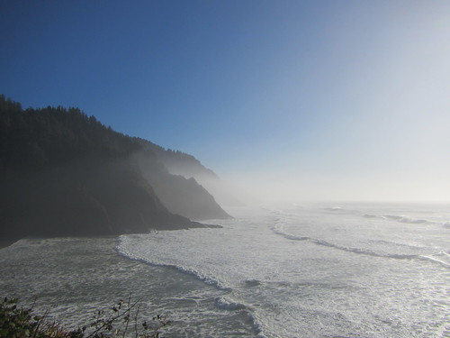
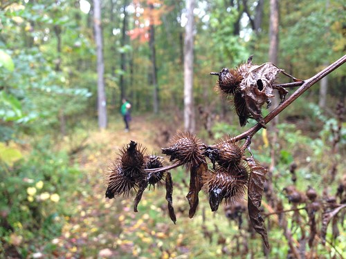
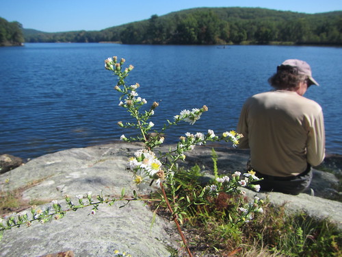
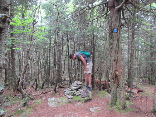
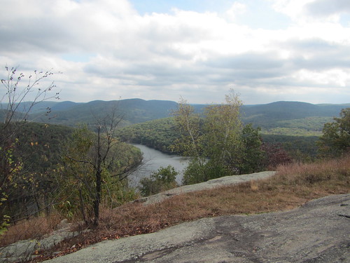
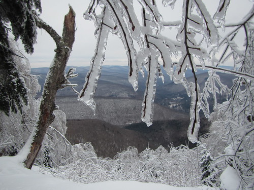
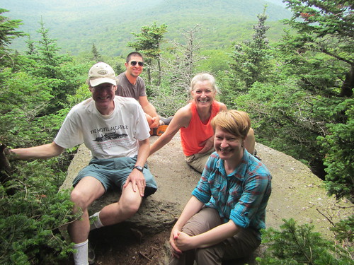
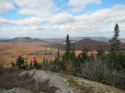
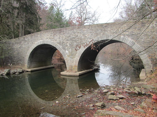
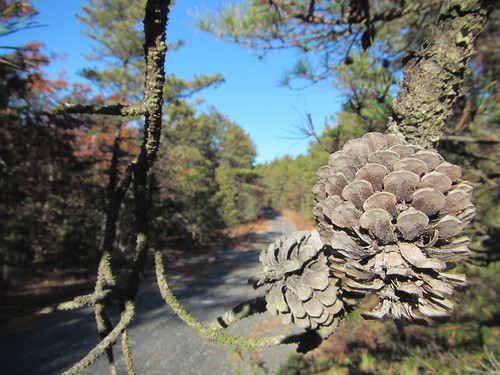
The New York Ramblers, like several other local clubs, have an annual tradition of hiking to the Torrey Memorial in Harriman State Park. This year, I was leading the hike for the second year in a row, using a different route. We had scouted it two weeks ago, which is when I took the above photo at the memorial.*

The weather for the official hike was not so promising. The forecast for the day had been holding steady with torrential downpours, vacillating on whether there would also be lightning and wind. I contemplated cancelling but was reluctant. For one thing, the previous week's hike had been cancelled. For another, last year's hike had stopped short of the memorial and turned around due to thunderstorms. I didn't want the hike to fail again.

Still, I must admit that as I waited at Port Authority, part of me hoped no one would show up.

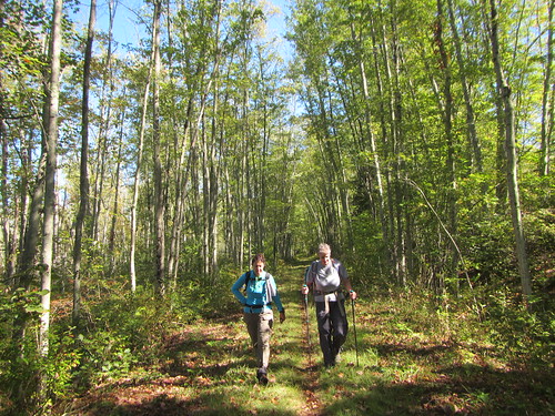
But, no - one hiker did. So we set off for Harriman on the bus that stops at Bear Mountain Inn before our stop, Fort Montgomery. Somehow, our driver managed to get lost on the way to Bear Mountain. Nevertheless we arrived, and faced only light rain to begin.

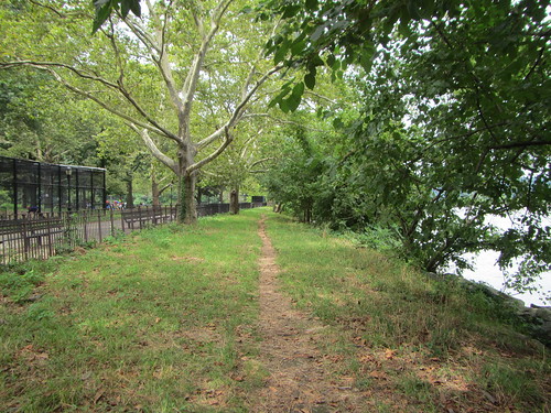
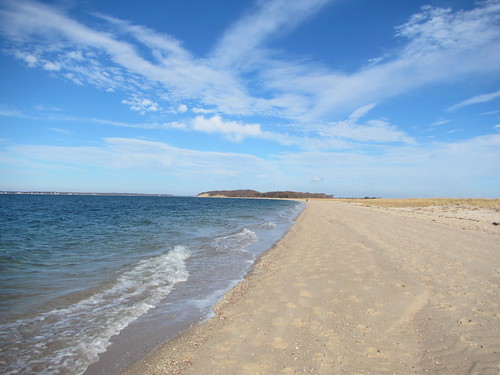
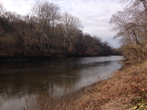
The plan, as it had been scouted, was to hike around Brooks Lake, through Popolopen Gorge, then take the most direct route to Torrey Memorial. From there we would keep heading west, joining the Long Path to a bus stop in Central Valley. Although only one trail passes over the memorial, there are several ways to get there (and several more that only make sense if you have a car). 

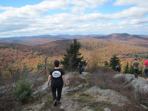
Over the course of the morning, the rain only let up very briefly. We had trouble finding a spot for lunch; my original plan of eating on the open mountaintop was of course out of the question. But there really is no shelter anywhere along the route. So we scarfed a quick lunch down under a dryish tree before finishing the climb.

Torrey Memorial

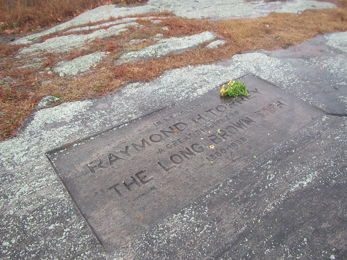
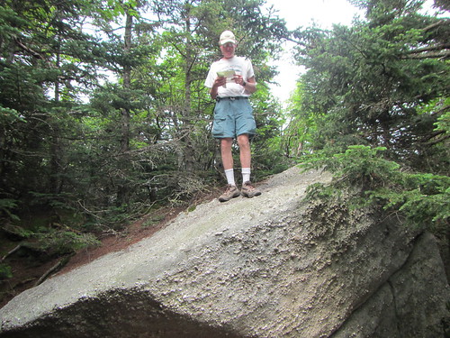
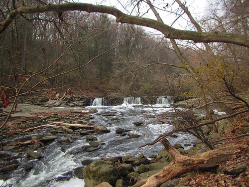
The above photo is of the memorial in the rain. We only lingered long enough to discuss what we should do. The second half of the hike was going to be much hillier, and wet leaves on wet rocks seemed like a recipe for danger. If we headed back, it would be easier and faster. I proposed turning around but instead following another trail through (although not up) Bear Mountain to the Inn. While I had never done it, it seemed straightforward enough. My fellow hiker agreed, so we set out.

Immediately the rain redoubled. I gave up on keeping my feet dry. I gave up on keeping my camera lens dry - there was nothing to dry it off with. Eventually, I gave up on calling it a "hike" altogether, repeating to myself like Dory, "Just keep swimming, just keep swimming."

We made it back to the Inn in time to change into dry shirts - I even had a hot chocolate - before catching the return bus. (Naturally, we had the same driver on the way back, and he asked us how much our fare was.) Both of us were glad that we'd be back to the city almost two hours earlier than planned, thanks to the route change.

If I lead this hike next year, I fully expect, like, a sharknado.

* I neglected to blog about it, it would seem.
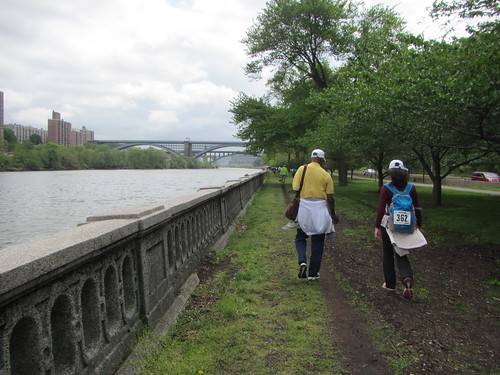
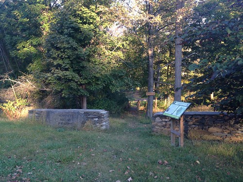
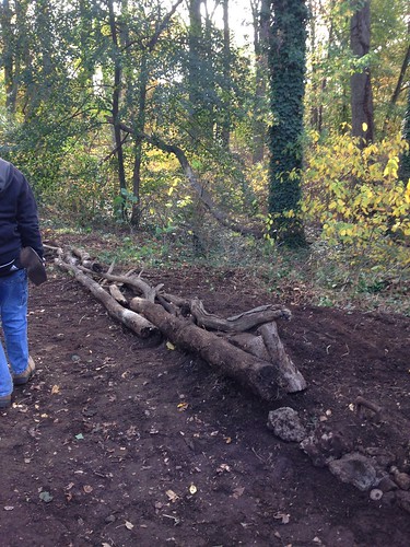
Thursday, October 26, 2017

Hiking to Heceta Head

Heceta Head Lighthouse

I've just returned from a trip to Oregon, during which it mostly rained. However, on the one nice day I was there, my sister and I went to the coast. We traipsed along the ocean and we also visited Heceta Head Lighthouse. I thought I had been there previously but was confused. (To give myself some credit, the buildings look similar, and on my previous visit, the fog totally obscured the view.)

From the parking lot, we strolled half a mile uphill to the lighthouse. The view above is from partway up the trail. The lighthouse itself looked reasonably cool, although we didn't tour it. For one thing, we had her dog with us, and for another, the tower was closed for lens repair. But the view itself was a sufficient reward.

Sunday, October 15, 2017

Hiking Coney Mountain (Tupper Lake 1 of 3)

Coney Mountain

With beautiful weather last Sunday, we decided to head up to the top of Coney Mountain. Yes, it's a mountain. Yes, it's uphill most of the way. But it's also only one mile, and that mile isn't particularly steep. And the views from the top are 360 degrees of panoramic goodness.

As you can see, we didn't exactly have it to ourselves. That wasn't unexpected, given the nature of the hike. Still, it was totally worth it.

Click here to see a video of the top!

Friday, October 13, 2017

Hiking Haystack (Saranac 6 no. 5)

Haystack Mountain

After our quite Hyde Park hike, and after a night in a horse-racing themed hotel halfway to the Saranac Lake area, we drove up to the Adirondacks to climb the next peak in our Saranac Six quest.

Haystack (not to be confused with the other Haystack, an Adirondack high peak) starts from the same parking area as the main route up MacKenzie, the hardest of the six. We set out not sure what to expect; it was a greyish day, and we weren't sure we'd have any view awaiting us at the top.

The climb is relatively easy from a technical point of view - not a lot of scrambling. The hardest part is crossing the stream below a dam relatively early in the hike. We enjoyed our new poles, however, as they provide a slight assist.

Near the top, there is a small ledge with a view. There we met a couple from New Jersey who were hiking with their Yorkie, who they are aiming to make the smallest Saranac 6er. He (and they) have one peak left. 

From there, it is a short distance to another viewpoint, not technically the top but very close. We were pleasantly surprised that despite the grey day, the view was not totally socked in. We enjoyed the view before heading down to a local brewery for dinner.

Thursday, October 12, 2017

The Hyde Park Walkabout

Winnakee Nature Preserve

J and I went to the Adirondacks this past weekend and did some fun hiking in the mountains, but we also sandwiched our trip with two easy hikes in the Poughkeepsie area. She had discovered the Hyde Park Walkabout, which rewards you for doing five local hikes with an annual patch.

Both of the hikes we did were about a mile long and mostly flat. On Friday, we went to the Winnakee Nature Preserve (above) for a quick evening hike. On Monday, we ended a rainy day with a hike at Val-Kill, Eleanor's Walk (below). Both of these are loop hikes through the woods - pretty and pleasant.

Eleanor's Walk

Tuesday, October 3, 2017

Hiking in Basha Kill

Rambling

On Sunday, the Ramblers took a long bus ride up to Wurtsboro to hike in an area that's generally hard to reach by public transit. After a road walk, we got on the Long Path/Shawangunk Ridge Trail, part of which is an old canal towpath, and which in this area is mostly flat.

We soon reached an area J and I had previously done a birdwatching stroll in, then continued on past wetlands.

Wetlands

Eventually, the trail heads uphill through Gobblers Knob State Forest. After leaving the forest, we proceeded a bit further before taking an old road to the Otisville railroad station.

Let's ride the train

Okay, okay, that's not the actual train station - it's a park in Otisville maybe half a mile before the station.

Saturday, September 30, 2017

A flat hike in Harriman

Lake Sebago

"Flat" and "Harriman" aren't usually seen together, but last weekend's Ramblers hike was in fact mostly devoid of hills - aside from a long descent at the end. We started at Sloatsberg, wended our way along the western shore of Lake Sebago, and ended at Tuxedo. Along the way we encountered a nice creek, a second lake, and the Victory Trail, a trail I rather enjoyed for its wide, easy walking.

Friday, September 22, 2017

Visiting the Albany Pine Bush

Albany Pine Bush

After the Catskills, we headed up to Albany - my first time there. Our first stop was the Albany Pine Bush, a preserve for an endangered ecosystem. J hoped to see some fun birds, although our chances weren't good, since we visited in the heat of the afternoon.

We did a 2.6-mile loop hike, mostly flat, at a leisurely, bird-spotting pace. As predicted, we didn't see any new birds. I did get some nice flower photos.

Also, we didn't see the Karner Blue butterfly, one of the original impetuses behind the preserve - it wasn't the right season for them. But it would be fun to visit again at another time of year.

Thursday, September 21, 2017

Hiking Panther when it's not winter

Giant Ledge and Panther

I have hiked Panther twice in the past, both of those hikes in winter under snowy conditions. I was curious to see what it was like in another season. Turns out it's great year-round.

It's one of the gentler slopes in the Catskills. (You're still climbing a mountain, of course.) That makes it very popular - or at least the first half of it, to Giant Ledge. Giant Ledge is a flat peak with a cliff on the eastern side, making for many fine views. The NY/NJ Trail Conference map shows three views; another hiker referred to four or five; we counted 11 ledges, plus one view that was not a ledge. The photo above shows one of the views.

Much of the traffic turns around after the Giant Ledge, and the trail heads downhill into a small col before turning up to Panther. The peak of Panther isn't as exciting as Giant Ledge, nor is it as clearly marked. (Last time I was there, the leader said, "I think this is it, not sure.") There is a small view at or near the top.

The leaves were just starting to turn on our hike. I imagine in a few weeks it will be truly spectacular. It is also quite nice in winter, but unlike some Catskills peaks, you don't need winter to have views.

Friday, September 15, 2017

A visit to Sag Harbor

The beach

Thursday, August 17, 2017

Hiking from Cortlandt to Scarborough

Oscawana Point

This week's Ramblers hike started at Cortlandt, wound through several parks, and then headed south to Tarrytown. A few of us cut it short at Scarborough, however.

There was much less road walking than I expected (although a fair bit of paved greenway), and the hike was mostly flat, particularly in the second half. Some of the parks we wended our way through were more scenic than I expected, like the short trail to Oscawana Point, shown above.

After having lunch by the Hudson, we more or less headed straight south, eventually joining up with the Old Croton Aqueduct. By the time we exited at Scarborough, we had hiked 16 miles, with supposedly three more to go. They ended up hiking seven more, so I'm glad I cut out!

Monday, August 7, 2017

Inwood Park stroll

I had planned a bigger hike for Sunday but ended up under the weather, so I did a short stroll around Inwood Hill Park.

Path

On the way there, I went through Isham Park and discovered a garden I hadn't seen before - Bruce's Garden. It was quite charming. Below is what I assume is a student art project in the garden.

Pans

Friday, August 4, 2017

Prospect Park birding

Prospect Park

We went to Prospect Park to go look for birds. This, of course, is the Audubon Center on the pond.

Prospect Park

Here are some tiny little berries.

Prison duck

This guy is behind bars. Without a really great camera, you can't get good bird photos of smaller or faster birds, but ducks are easy.

Sunday, July 30, 2017

Visiting Mt. Utsayantha

Mt. Utsayantha

Mt. Utsayantha is a Catskills peak but under 3500 feet, and the only one you can drive to. It's also a pretty spectacular bit of cultural appropriation. Back in the day, the town of Stamford wanted to get its share of tourists, so it made up a story about an "Indian princess" who killed herself when her lover died in war. They built a fake grave, and an observatory on the mountain where she supposedly died.

The observatory is still there (visible in the photo above), although a newer fire tower has been built, and the signage acknowledges the fakery. The view from the top is quite nice, as you can see.

Saturday, July 29, 2017

Hiking Table and Peekamoose

Table & Peekamoose

I have only the vaguest recollections of previously hiking Table and Peekamoose. That's because I did them as part of The Six, and by the time we got to Table, we had already done four bushwhacks. I do remember literally kissing the trail, though, because I was excited to be on one.

This time, we did a shuttle hike from the Slide trailhead at Frost Valley Road to the Peekamoose trailhead on Peekamoose Road. At the Curtis-Ormsbee trail we made a slight detour. Well, actually, half our group went up the Wittenberg-Cornell-Slide trail and down Curtis-Ormsbee, while half of us turned up the Curtis-Ormsbee just as far as the second viewpoint. Neither viewpoint is particularly grand, although there is some steep climbing to get there.

From there we continued south. At one point we passed the eastern end of the Finger Lakes trail, which extends 580 miles through, you guessed it, the Finger Lakes, all the way to the border with Pennsylvania.

The hike is half over by the time one reaches Table, and from there it's a short jaunt to Peekamoose. Both have views, but neither have views right at the peak. The top photo is the summit of Table, and the bottom photo is the summit of Peekamoose.

On the way back to the car, we supposedly pass Reconnoiter Rock, which caused us the same doubts as Cornell Crack - there are so many rocks, why name this one? In this case, we weren't even sure which rock was Reconnoiter. But it's a long three miles out to the end of the trail - I guess we needed something to keep us on the lookout.

Table & Peekamoose