Wednesday, July 30, 2014
Tuesday, July 29, 2014
Hike to Lake Isabelle
 After a day back in Denver to catch up on things, I did a solo dayhike to Lake Isabelle. The hike is listed in 100 Classic Hikes in Colorado and for good reason. It's not, as far as Colorado goes, a strenuously killer hike, but the rewards are tremendous.
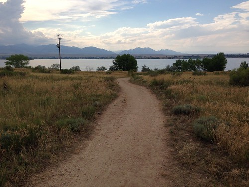
The trailhead lot was full, so after paying my $10 entrance fee I had to park at the day use area. I walked the long way around Brainerd Lake to the Niwot Cutoff Trail to catch the trail to Lake Isabelle. Along the way, I passed the north side of Long Lake; the trail offered many scenic glimpses of the lake. Past Long Lake, the trail climbed above a waterfall to Lake Isabelle, shown in the photo - an incredible beautiful lake with steep mountains rising on three sides. I continued on the trail until it started to climb away from the lake.
On my return, I took the Jean Lunning Trail south of Long Lake. It was considerably wetter than the north side, with more wildflowers as well as boardwalks through marshy areas. Finally, when I got off the Niwot Connector Trail, I elected to walk the short way back to my car, which was an excellent choice - four moose were grazing just a few feet off of the trail. Moose!
Monday, July 28, 2014
Rustler's Gulch hike
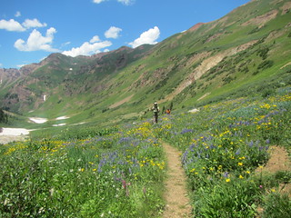 The hike to Rustler's Gulch was supposed to be our big wildflower hike, but previous day's hike to Ice Lake had already blown our minds. Rustler's Gulch was certainly pretty, and it had more wildflowers, but less variety.
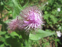
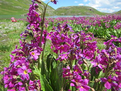
We started off on an old jeep road. If you have a high clearance vehicle, you can park at the actual trailhead, but that was not us. This was also the steepest part of the hike, although overall it wasn't nearly as steep as either of the previous two days' expeditions.
Also working against the hike was that we were a little tired, as this was our fourth day of hiking; it was hotter than it had been, and the hike had little shade; and the number of bees, which anyone who has hiked with me can attest to my, er, lack of fondness for.
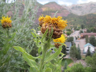
In spite of that, it was a very nice hike. We saw a field of ice lilies and several nice century plants, and the ground was veritably carpeted in yellow and purple. This photo is representative of most of the hike: long vistas with a profusion of flowers.
Sunday, July 27, 2014
Ice Lake and Island Lake hike
 This hike was highly recommended by my friends, and it actually exceeded their expectations.
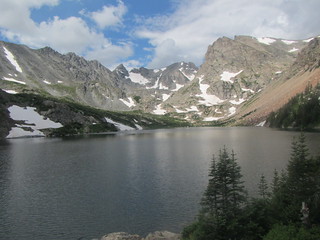
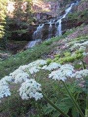
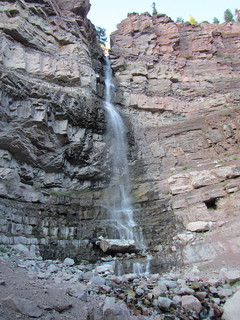
It started off promising when we were still in the parking lot, with hills rising up on all sides. From there, the trail headed uphill and entered the woods. The woods were very nice, but the first major attraction was the waterfall pictured at left. From there, the trail went in and out of woods, with rocky hills rising up around us. An old mine (of course) was a slight diversion, as were the abundant wildflowers we encountered. The trail emerged from the woods into a valley, where we crossed and re-crossed an unusually white stream. The stream pours out of Ice Lake, both deriving their colors from minerals.
 After a brief respite in the valley, the trail headed up again on slopes too steep for trees. We kept pausing to take wildflower flowers along the way, but eventually we reached the cirque with Ice Lake.
After a break, we decided to head on to Island Lake. You can also reach nearby Fuller Lake, but Friend C said it wasn't particularly exciting. Island Lake turned out to be very worthwhile. It has the same turquoise color as Ice lake, with, as you might expect, a small island in the middle. There were abundant pink flowers growing by it that perfumed the air. From there, we reluctantly turned around and headed back down.
 The hike was 4.2 miles one-way, with significant elevation gain; it was the highest I had ever hiked, above 12,000 feet.
It was well worth it, though. This hike checked off nearly every box for
a great hike: waterfalls, mountains, scenic vistas, lakes, dramatic
rocks, and wildflowers. The wildflowers in particular were a surprise,
as my friends weren't anticipating them in such abundance and variety. We also discovered the existence of the hummingbird moth, which is exactly what it sounds like; picture a hummingbird with antennae, and you've got the hummingbird moth. Overall, it definitely rated as one of the best hikes I've done.
The hike was 4.2 miles one-way, with significant elevation gain; it was the highest I had ever hiked, above 12,000 feet.
It was well worth it, though. This hike checked off nearly every box for
a great hike: waterfalls, mountains, scenic vistas, lakes, dramatic
rocks, and wildflowers. The wildflowers in particular were a surprise,
as my friends weren't anticipating them in such abundance and variety. We also discovered the existence of the hummingbird moth, which is exactly what it sounds like; picture a hummingbird with antennae, and you've got the hummingbird moth. Overall, it definitely rated as one of the best hikes I've done. Saturday, July 26, 2014
Perimeter Trail to Cascade Falls
 This one was so short, it doesn't quite qualify as a hike. I even did it in flip-flops. Neverthless ...
After dinner on day two, Friend D and I elected to go see Cascade Falls. A sign on Main Street pointed the way, and the trail was supposedly only a quarter mile. In this case, our hike to the hike was longer than the hike itself! The hike was probably not even a quarter mile. To the base of the falls was just a hop and a skip from the parking spot; we then followed the Perimeter Trail as it switchbacked to about halfway up the falls. From there, the trail turned away from the falls, so we headed back down.
If you aren't really a hiker, you could do this hike - even with various mobility issues, short of a wheelchair, at least up to the base of the falls. And it is an impressive drop.
Friday, July 25, 2014
Bear Creek hike to Grizzly Mine
 My friends had two particular hikes in mind, but we had three days, so we asked the proprietor of the local gear shop for advice - something for three fit hikers, but one that wouldn't tax the poor sea-level gal. One of his suggestions was the Bear Creek trail as far as the Grizzly Mine, 2.4 miles one way, which didn't go above 10,000 feet.
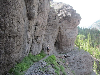
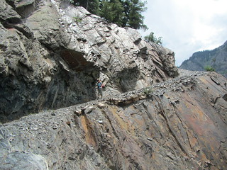
The trail began by crossing the highway over a tunnel before heading up the side of a canyon. The first half or so is cut into a steep slate hillside. While the trail was rocky, it was flat slate that clinks pleasantly underfoot. The walls of the canyon were so severe that there were impressive views even in the trees. Eventually, the trees petered out altogether. The trail was exposed along the right side, although the trail was wide enough to assuage anxiety. (Mind you, I wouldn't want to do it drunk or at night.) We reached the remains of the mine and poked around. The mine shaft was actually visible, although gated and locked.
 The trail is named for the creek it runs above, but the key is "above" - we would have had to rappel down several hundred feet to refresh our water bottles. As we hiked, we mused about how hard it would have been to build the trail; turns out the trail was built by miners, in places using dynamite.
The hike was sparser in vegetation than the rest of our hikes, which made it interestingly different. There were a few wildflowers, actually, but it's not a flower hike. Do this one for the spectacular views and the ledge-walking, which looks much more fearsome in photos than it does on the trail.
Thursday, July 24, 2014
Perimeter Trail hike around Ouray
 I'm in beautiful Colorado right now. I spent the first four days of the trip hiking with old Nashville Hiking Meetup friends who live in the Denver area. On Sunday we drove out to Ouray, a really beautiful tiny town with mountains looming over it. After finding a hotel and having dinner, we decided to take a short postprandial stroll. The Perimeter Trail, which circles the city, was close by; Friend C had done part of it before and said it wasn't amazing, but it would get us started.
We walked up the street (a literal statement) to where we could connect with the trail on the west side of town. This part of the trail was very nice. First, there were views of town (pictured). Then, we entered Box Cañon, where the rock walls narrowed in close and a waterfall tumbled down. Finally, we thought we'd catch another loop of trail before heading back into town.
Unfortunately, the last bit took longer than anticipated; we think we wandered onto the Ice Park trail by mistake. In any case, we were quickly running out of light, so when we intersected the highway we took it back into town.
While these numbers aren't precise, we figured we hiked 3-4 miles with about 500 feet of elevation change. Now, this was actually the second-easiest hike we did all trip - the first easiest being a 1/4 mile jaunt. However, it was the hardest for me. I was working on two hours of sleep, had been up since 3 a.m. Eastern, and had been at sea level that morning. Spoiler: A good night's sleep would work wonders for the next day.
The hike was quite nice, though, and Friend C agreed it was much better than what she had seen elsewhere on the trail.
Thursday, July 17, 2014
Harriman traverse
 On Sunday I hiked with the Ramblers across Harriman State Park, west to east. We started in Arden and ended in Mt. Ivy for a total of 16 miles.
The hike itself was pretty but nothing spectacular. The views typically available at Big Hill shelter was obscured by the grey weather, and otherwise we were mostly hiking through forest, with the occasional interesting rock formation.
The final leg of the hike left Harriman and entered Cheesecote Park, then left that park and followed the Palisades Interstate Parkway. At the scale of the NY-NJ Trail Conference maps, it looks as if the road is the trail, hardly a good idea on the PIP. In fact, the route goes through the woods next to the parkway, but it's quite miserable. Someone slapped up some blazes and called it a trail, rather than doing the hard work of grading, smoothing, and otherwise making the ground treadworthy. It's essentially bushwhacking with signs.
While not the most spectacular hike I've done, the weather held off and we didn't get rained on, and the company was good.
Tuesday, July 1, 2014
Catskills: Logistics
 Until now, I hadn't been to the Catskills for lack of a car. It's not readily accessible by mass transit - although that doesn't mean it can't be done. I saw Trailways buses in both Tannersville and Phoenicia. Still, it would be a hike to any campsite. That doesn't mean it can't be done. John at the Hunter fire tower told me about a 71-year-old retired teacher from Queens who had done all the Catskills 3500 peaks via bus, train, hitchhiking, etc. Furthermore, she had done what he called "the grid" - each of those 35 peaks in each of the 12 months of the year. You do the math on that one.
My commitment to car-free living isn't as rigorous as that, though. I merely took a train to Poughkeepsie and rented a car there. (I had zero desire to drive out of Manhattan.)
That meant, though, that I had to keep my equipment light; not quite backpacking weight, but I only had a large suitcase and a day pack. Practically speaking, that meant buying food in Poughkeepsie and, perhaps more importantly, no cooler: I drew the line at buying and tossing a cheap styorofoam cooler. No comfy camp chairs, no endless wardrobe choices.
I chose to stay at Devil's Tombstone, which is a primitive campground near North-South Lake. "Primitive" is accurate: pit toilets, pumps but no running water, no RV hookups. The pictures on Reserve America made it look quite pretty. And you can drive a few miles and shower at North-South Lake. I hoped a primitive site would have quieter campers.
What the pictures don't make clear is that the pretty little pond at Devil's Tombstone is in the day use area, not within view of the campsites. It was my bad luck, further, that the two sites across from mine were occupied by one large group of college kids. Their idea of camping was to drink beer, adorably struggle to make fire, and go on one hike without being adequately provisioned and then moan about it. Oh, yeah, and to play their music until 2:30 in the morning, even though quiet hours start at 10 p.m. - the attendant on duty Friday night did nothing to keep the sound down. Saturday was better. Sunday night it was remarkably quieter, as nearly everyone left.
Next time I'd stay at North-South Lake. The sites are just as nice, the noise didn't seem to be any louder - rather more kids, though, I'd expect - and it's worth not having to drive just to flush the toilet and shower off the grime.
Subscribe to:
Posts (Atom)