Monday, June 29, 2015

Hiking Fire Island

Beach walk

This hike was a dry run - somewhat literally - for a swim hike I'm leading for the Ramblers in August. We took the ferry to Watch Hill and, after touring the salt marsh, walked between the dunes and the southern shore for five miles to a breach created by Hurricane Sandy. Because the day was cool, we didn't stop to swim at the beach or to wade along the way.

I'm curious to see what it looks like on a warm, sunny day; hopefully I'll find out when we repeat it in August.

Thursday, June 25, 2015

Storm King Art Center

Schunnemunk Fork

Today the Ramblers took advantage of a free day at the Storm King Art Center. This was quite different from the group's usual hikes - less strenuous, more arty. The above photo is part of a piece called Schunnemunk Fork by Richard Serra.

Sunday, June 21, 2015

Hiking "The Six"

I started the Catskills 3500 peaks a year ago today. As I am now halfway through, the logical conclusion is that it’ll take another year to finish. On the other hand, if I continue at yesterday’s pace, it’ll only take three days. That’s because yesterday I hiked “The Six” - Friday, Balsam Cap, Rocky, Lone, Table, and Peekamoose - with the Catskill 3500 Club.

I will not finish in three days.

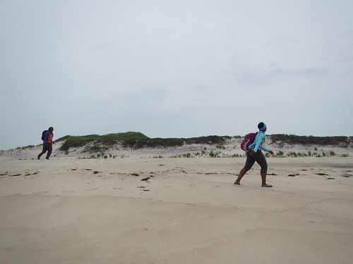
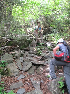
The hike appealed to me because of its near-German efficiency in peak-bagging: six peaks in only one 12-mile hike! Also, four of the six peaks are trailless and take good navigation skills, which I’m happy to outsource to experienced trip leaders. Of those 12 miles, about four are on trails, mostly at the end. The first quarter-mile or so up to Friday is technically trailless, but it follows an old road. The rest is navigation either by compass or landmarks. Navigation is made more complicated by stone cliffs as well as a bit of private property near the beginning.

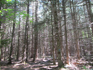
The hike started off with a strenuous ascent up to Friday from Moon Haw Road. This would be the biggest elevation gain of the day, as the cols between the peaks aren’t deep. There were some rocky ledges, but the bushwhacking wasn’t dreadful. 
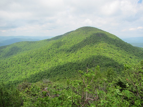
From there it was on to Balsam Cap, which involved much thwacking of the face with branches. Most of these peaks have eastern views at or near the top, but the day was cloudy with fog rolling in.

From Balsam Cap we continued to Rocky, a journey filled with very thick balsam. Bushwhacking through this is a slow and (occasionally) painful process; a dead branch randomly fell on my head at one point. After Rocky came Lone. Supposedly, this is the thickest of the bushwhacks, but our leader steered us clear of the worst of it, earning enormous accolades from the hikers who had done it before. By this point it was raining, though, and I'd reached my fill of fighting branches while simultaneously not tripping on roots.

From Lone, we headed towards the trail between Table and Peekamoose. When we finally saw the trail, it was like sailors reaching land. The ground was so smooth! So easy! So not in our faces! Even if it was uphill to the flat top of Table. Then backtracking down and continuing on to Peekamoose. All views were utterly obliterated at that point by clouds. Luckily, the tree canopy kept most of the rain off of us, so we weren't any wetter than we would have been from sweating on a warm day.

The trail back to the cars seemed interminable. Everyone was a bit cooked at that point. However, we were all glad to be proceeding down gentle trail rather than than the steep path we had ascended initially.

GPS apps called our final mileage between 12.7 and almost 15, so it was likely more than the estimated 12. It was a rough 12-15 miles though, between the extensive elevation gain and the bushwhacking.

By the way, there is an extended version of The Six - The Nine, which adds on Slide, Cornell, and Wittenberg. I have no intention of doing that. This was a tough enough day for me, and anyway I've done all those peaks. The remainder of my excursions are probably no more than two peaks at a time, which is fine with me.

Saturday, June 13, 2015

Highbridge reopens to pedestrians

High BridgeAfter 40 years, NYC finally reopened Highbridge this week. The pedestrian-only bridge crosses from east Harlem to the Bronx.

Harlem RiverFrom the bridge, there are nice views (this is looking south at the Harlem River).

ViewpointOn the Manhattan side, it ends in Highbridge Park, which has an old water tower, a pool (not yet opened), and some bike and pedestrian trails. The park is on a steep rock outcropping, which falls away rapidly on the east side.

StairsAt the south end of the park there are stairs connected the (lower) east side with the (higher) west side, but do note: The east side runs along Harlem River Drive, a road that is both busy and desolate, totally unshaded, and goes nowhere. (At least, the sidewalk peters out; the road goes on.)

Thursday, June 4, 2015

Hiking the Blackhead Range

ClimbingThe Catskills' Blackhead Range including three 3500 peaks: Blackhead, Black Dome, and Thomas Cole. I had caught a view of them on my Windham hike the previous day, lined up in a row.

There are several possible approaches to these peaks. We took the steepest one, starting up the Batavia Kill Trail to Blackhead. Unlike Windham, this trail was pure Catskills - rocky and steep. (Blackhead is also a required winter peak; that approach is not recommended in winter.) From there, the climbs to Black Dome and then Thomas Cole are equally arduous, if shorter. There are some nice views, although the best aren't necessarily from the top - the view below is of Black Dome, taken from the descent off Blackhead. On Thomas Cole, you can look out to the north and see Windham High Peak.

The descent from Thomas Cole was actually much more moderate. Since we had multiple cars, we were able to do a traverse with a car shuttle. It would be a much more challenging hike if one had to hike the peaks again on the way out!

View of Black Dome

Monday, June 1, 2015

Windham High Peak hike

Hemlock forestWindham High Peak is surprisingly easy for a Catskill peak, which you might not expect with the "high" in its name. But the ascent from the northern end of the Escarpment Trail is gentle and surprisingly unrocky.

Nevertheless, I did have a few moments of confusion when, near the beginning, a bike trail area splits off to the left. I knew that the Escarpment Trail went right, but unfortunately there isn't a blue blaze visible at the split; I thought the actual trail was just an unofficial side trail. Once I cleared that up, following the trail was easy. It climbed through deciduous forest and hemlock groves until it finally reached the peak. The views are somewhat obstructed by trees, but there is still a nice view south of Blackhead, Black Dome, and Thomas Cole mountains.

SalamanderI was tempted to continue on to Acra Point and Burnt Knob, as the view from the former is supposed to be splendid. I stuck to my plan of "taking it easy," though; I didn't want to tire myself out before the next day's big hike. I reluctantly turned around.

One thing I like about hiking alone is that I get to see more, especially more wildlife. One person is simply quieter than six or a dozen. Coming down Windham, I got to play paparazzi to this orange salamander, who obligingly sat for a close-up.