Saturday, June 30, 2012
Monday, June 25, 2012
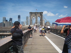
Crossing the Brooklyn Bridge
Walking across the Brooklyn Bridge is a classic NYC activity, so when a Tennessee friend was in town, we did just that. (He's a hiker, so no complaints about how much walking there is in the city!) The experience was a letdown, and I think I prefer the GW crossing.
Two things made the crossing less pleasant that you ought to keep in mind. One, it was hot. Choose a cooler day than I did if you go. Two, there is construction that blocks views on much of crossing. Wait until it's finished to go - that should be 2014, incidentally.
The Brooklyn Bridge is a big tourist draw, and you may prefer being part of a crowd or not as you please.
Even with these caveats in mind, I think the GW crossing is superior. It has fewer people and more spectacular views. The views from the Brooklyn Bridge are along the lines of, "Oh, look, that's the Statue of Liberty." Nothing to sneeze at, but not as panoramic.
More irritatingly, while you enter the bridge in Manhattan very close to the water, on the Brooklyn end you are trapped in the middle of a road well after it hits the ground. For several blocks you're on an unshaded concrete walkway with views of office buildings. For that reason, many people don't go all the way but turn around and head back to Manhattan.
I can say I've done it, but I won't be taking any more visitors across until the work is done.
Friday, June 22, 2012
Circumnavigating Manhattan, part II
Remember back in April, when I attempted to walk around Manhattan? I've been intending to go back and finish the remaining eight miles, and today was the day I had marked on my calendar.
The problem was, the forecast called for temperatures hitting 100, with thunderstorms in the afternoon. Not exactly ideal weather for walking a trail that is mostly unshaded.
I decided I would attempt it, but I wouldn't be in any hurry, and I'd bail at any point I chose. There's no need to prove I can make eight miles, after all, and the greenway ought to still be there later. So I set out from the 101st St. underpass to the greenway with sunblock on and plenty of water.
I ended up going about 2.5 miles, to 68th St. At that point, I realized I just wasn't enjoying myself, exotic scenery notwithstanding.
That means I still have the remaining 5.5 miles to go to South Ferry for another (cooler) day.
Thursday, June 21, 2012
Tuesday, June 19, 2012
Guest blogging
I am doing some guest posts over at How to Run a Meetup. They're written from the point of view of the member, but one who knows what it takes to run a meetup. The first one, now up, is on event descriptions.
Armchair scenery
So, I have a Tumblr now full of pretty nature pictures. You should totally go look at it.
Sunday, June 17, 2012
Hiking the Long Trail through New Jersey
It was with great excitement that I discovered a Death March close to home, just across the Hudson River from upper Manhattan. One could take the Long Path from Fort Lee all the way up to the New York state line, then return via the Shore Trail. 24 or so miles, although mostly flat? Perfect. Then this spring a landslide wiped out the Giant Staircase near the north end of the Shore Trail. As of now, that area is still closed. But that gave me the opportunity for a less deathy long hike, simply doing the first half. This is a good overview of the precise hike I took. That website, incidentally, is more informative than the NY/NJ trail conference or the official interstate palisades commission website.
I took a NJ Transit bus ($1.70) over the bridge. I'm not sure it's actually faster than walking, but it is indubitable that it saves you from having to walk. I didn't appreciate this outbound as much as I would coming home, of course. You exit at what is called GW Plaza West , walk a couple of blocks back, cross a busy street, and there you are. (Just keep aiming for the bridge.) Technically, the Long Path begins in Fort Lee on the south side of the bridge; this is a relatively recent change.
The beginning of the trail is nothing spectacular. It's woods, so it's pleasant enough, and I encountered quite a few morning joggers. For about 11 of the next 12.7 miles, the Palisades Interstate Parkway will be close by on your left, at times only 10 feet away. On your right are the cliffs that made it a park in the first place. You can't see them, though, because you're on top of them.
About every mile or so there will a lookout where you can see Manhattan, then the Bronx, then Yonkers, along with the Hudson River in between. The bigger view spots have parking and in some cases amenities such as restrooms. Near the beginning is also St. Peters College, the only private land you'll encounter along the hike.
The trail then passes between two nature preserves. On the other side of the highway is a public preserve; between the trail and the Hudson is the Greenbrook Sanctuary. The Greenbook Sanctuary was marked "members only" on the map. In my imagination, this was a very elite organization, a club of Rockefeller descendants feeding ivory-billed grosbeak turtles out of Ming teacups. In fact, the organization had free newsletters at their gate, and it seems that you can become a member for the utterly reasonable price of $35. The trail as it passes through here is quite beautiful. It's also where I encountered my first modest hills. The trail is much prettier through here than it was at the start.
The trail maps show that the Zabreski ruins are coming up. They are only the best preserved of a series of old house foundations.
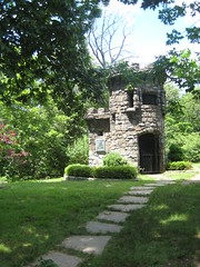 You are more than ⅔ of the way there when you reach the Women's Federation Monument. Women's clubs were instrumental in getting this area preserved. You can go inside and on top of the castle. At this point, you may notice that you are now farther from the road - the roar of traffic is almost entirely gone.
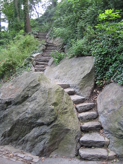
From here the trail gets hilly, including some enormous steps. The State Line Lookout is not, in fact, at the state line. A little farther, the Border Monument is apparently at or near the line. It was also a monumental disappointment. I may or may not have gotten lost around here. Tip; at the monument, turn right. It feels totally counterintuitive, but do it anyway. Now let us never speak of that again. The trail here has many stairs, and then hills without stairs. Then you pop out of the woods onto route 9W, at the entrance to Columbia's Lamont Observatory.
To get home, I had to play Frogger across the busy highway and wait for a Rockland Coach bus.(Google Maps doesn't pull this up as public transportation, FYI.) I told the driver I wanted to go to the GW Bridge, and he said the bus didn't go there, but it did go to "41st or the Plaza." I said, "the Plaza," hoping that it would mean what I just said, and indeed it did. (Fare: $2.70.)
This trail is by no means wilderness, but it is surprisingly nice given that it is a narrow stretch of land by a highway. It's also easy to get to from the city, and at a lower price tag than many other hikes.
I took a NJ Transit bus ($1.70) over the bridge. I'm not sure it's actually faster than walking, but it is indubitable that it saves you from having to walk. I didn't appreciate this outbound as much as I would coming home, of course. You exit at what is called GW Plaza West , walk a couple of blocks back, cross a busy street, and there you are. (Just keep aiming for the bridge.) Technically, the Long Path begins in Fort Lee on the south side of the bridge; this is a relatively recent change.
The beginning of the trail is nothing spectacular. It's woods, so it's pleasant enough, and I encountered quite a few morning joggers. For about 11 of the next 12.7 miles, the Palisades Interstate Parkway will be close by on your left, at times only 10 feet away. On your right are the cliffs that made it a park in the first place. You can't see them, though, because you're on top of them.
About every mile or so there will a lookout where you can see Manhattan, then the Bronx, then Yonkers, along with the Hudson River in between. The bigger view spots have parking and in some cases amenities such as restrooms. Near the beginning is also St. Peters College, the only private land you'll encounter along the hike.
The trail then passes between two nature preserves. On the other side of the highway is a public preserve; between the trail and the Hudson is the Greenbrook Sanctuary. The Greenbook Sanctuary was marked "members only" on the map. In my imagination, this was a very elite organization, a club of Rockefeller descendants feeding ivory-billed grosbeak turtles out of Ming teacups. In fact, the organization had free newsletters at their gate, and it seems that you can become a member for the utterly reasonable price of $35. The trail as it passes through here is quite beautiful. It's also where I encountered my first modest hills. The trail is much prettier through here than it was at the start.
The trail maps show that the Zabreski ruins are coming up. They are only the best preserved of a series of old house foundations.
You are more than ⅔ of the way there when you reach the Women's Federation Monument. Women's clubs were instrumental in getting this area preserved. You can go inside and on top of the castle. At this point, you may notice that you are now farther from the road - the roar of traffic is almost entirely gone. From here the trail gets hilly, including some enormous steps. The State Line Lookout is not, in fact, at the state line. A little farther, the Border Monument is apparently at or near the line. It was also a monumental disappointment. I may or may not have gotten lost around here. Tip; at the monument, turn right. It feels totally counterintuitive, but do it anyway. Now let us never speak of that again. The trail here has many stairs, and then hills without stairs. Then you pop out of the woods onto route 9W, at the entrance to Columbia's Lamont Observatory.
To get home, I had to play Frogger across the busy highway and wait for a Rockland Coach bus.(Google Maps doesn't pull this up as public transportation, FYI.) I told the driver I wanted to go to the GW Bridge, and he said the bus didn't go there, but it did go to "41st or the Plaza." I said, "the Plaza," hoping that it would mean what I just said, and indeed it did. (Fare: $2.70.)
This trail is by no means wilderness, but it is surprisingly nice given that it is a narrow stretch of land by a highway. It's also easy to get to from the city, and at a lower price tag than many other hikes.
Friday, June 15, 2012
The cost of hiking travel
When I lived in Tennessee (and Indiana, and Washington), I reached all of my hikes via car. Not always my car, but never by train or bus. Now, I almost always take public transit, since I don't own a car, and I haven't yet made really good hiking friends. I haven't yet figured out which is more cost effective; it really depends on how often you hike and where you go. The cost structure is quite different:.
There are other important factors besides cost; some hikes just can't be reached by public transit. Also, taking the train requires more planning, in many cases. Some stops are weekend only, with just one or two stops a day. You don't want to miss that train.
The net result is that it takes more forethought and planning to hike out of the New York city area without a car, and a couple of too many train hikes could quickly wreck your budget - an off-peak one-way ticket can cost up to $18.25 on the LIRR, $16.25 on Metro North, and over $20 on NJ Transit.
- When you have a car, every trip is a marginal cost. You're paying for the vehicle, maintenance, and insurance anyway - everything but the gas and possibly tolls. When you don't have a car, you pay the full cost every time to either rent a vehicle (plus gas and tolls) or take a train. Therefore, each trip feels more expensive.
- Very few true hikes can be reached via the NYC subway/bus system, but these trips are free if you already have an unlimited monthly pass.
- If you and four friends decide to take a car to a hike, the cost per person is divided by four (plus the negligible expense of extra fuel because of more weight). If you and four friends decide to take the train, there are no cost savings.
There are other important factors besides cost; some hikes just can't be reached by public transit. Also, taking the train requires more planning, in many cases. Some stops are weekend only, with just one or two stops a day. You don't want to miss that train.
The net result is that it takes more forethought and planning to hike out of the New York city area without a car, and a couple of too many train hikes could quickly wreck your budget - an off-peak one-way ticket can cost up to $18.25 on the LIRR, $16.25 on Metro North, and over $20 on NJ Transit.
Thursday, June 14, 2012
Van Cortlandt Park hike
Today, I hiked the John Muir Trail. No, not that one. No, not that one, either. Just a very short one in the Bronx's own Van Cortlandt Park.
VCP is large for a city park, but it's still no Appalachian Trail. Still, I managed to get lost at some point after I crossed under the Henry Hudson Parkway (see photo). It crosses quite a few other trails and is woefully short on trail markers. Not that I was Moses, exactly, in the wilderness for 40 years, but I ended up in the southeast corner of the park, not the northeast. The bonus was that I got to see a wetland, which wasn't shown on the map.
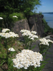
While the trail didn't pretend to be wilderness, it had some charming spots, as well as some nice flowers. However, it definitely needed some maintenance in spots, in addition to more markers. Some judicious pruning as well as litter pickup where it passes near the highway would do wonders. (You can volunteer here if you are a civic-minded New Yorker.) Still, it was in far, far better shape than the trail I encountered at Pelham Bay.
If you're a New Yorker, this park is worth visiting if you want to get off-pavement - especially if you're in the Bronx or northern Manhattan; coming from the eastern part of Brooklyn, it would no doubt be easier to get out to Long Island. The park is on the metro lines, so it's more affordable than heading out of town. And there are other unpaved trails at the park, which hopefully I'll be able to find next time. I've even heard tantalizing tales of a waterfall.
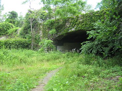
VCP is large for a city park, but it's still no Appalachian Trail. Still, I managed to get lost at some point after I crossed under the Henry Hudson Parkway (see photo). It crosses quite a few other trails and is woefully short on trail markers. Not that I was Moses, exactly, in the wilderness for 40 years, but I ended up in the southeast corner of the park, not the northeast. The bonus was that I got to see a wetland, which wasn't shown on the map.
While the trail didn't pretend to be wilderness, it had some charming spots, as well as some nice flowers. However, it definitely needed some maintenance in spots, in addition to more markers. Some judicious pruning as well as litter pickup where it passes near the highway would do wonders. (You can volunteer here if you are a civic-minded New Yorker.) Still, it was in far, far better shape than the trail I encountered at Pelham Bay.
If you're a New Yorker, this park is worth visiting if you want to get off-pavement - especially if you're in the Bronx or northern Manhattan; coming from the eastern part of Brooklyn, it would no doubt be easier to get out to Long Island. The park is on the metro lines, so it's more affordable than heading out of town. And there are other unpaved trails at the park, which hopefully I'll be able to find next time. I've even heard tantalizing tales of a waterfall.
Monday, June 11, 2012
Reading women: Mid-year update
Well, after reading Swamplandia!, Geek Love, and Mechanique, I think I'm good on circus/sideshow novels for a long time. (Of the three, I'd recommend Swamplandia! first.)
Another book of note I've read of late includes Zazen, which, yes, I did pick up at the store based on its cover, never having heard of it or its author. I highly recommend it to anyone who loves or hates hipsters, and to anyone who likes near-future sci-fi - although, really, it isn't.
I also read a pair of books that made a nice set, quite unintentionally. Almanac of the Dead takes place primarily in a variety of Arizona and Mexican locales and is in many ways a document of the effects of colonization and resistance on indigenous cultures. It's not a summer beach read. Giant, an older book, is about rich white cattle ranchers in Texas. While the locale and methods of colonial exploitation are different, Giant shows us the same forces at work in Almanac, but from the other side. (Almanac shows some rich white guys too, but they are all either drug/weapons dealers or in bed (usually literally) with them - the cattle ranchers occupy a higher notch in the social order.) Together, you can see why the descendants of the characters in Giant might want to ban writing by an author like Silko.
By the way, I had never heard of Edna Ferber, author of Giant, but she won the Pulitzer Prize for fiction back in the day.
Sunday, June 10, 2012
South Mountain Reservation for the win
While I've had some charming rambles in city parks, thus far I haven't been particularly overwhelmed by the proper hikes I've done in the greater NYC area. This all changed yesterday when I experienced the South Mountain Reservation in Millburn, New Jersey. It was, naturally, a hike that was pretty rather than one that offered major drama - it's not the Grand Canyon - but it was consistently pretty, with quite a few surprises along the way.
The 5.2-mile loop hike is easily accessible via NJ Transit, and it's a good one for novice hikers. The hardest part occurs straight out of the gate, when you have to head uphill on the Lenape Trail. Survive that, and the first major reward is an overlook of Millburn. The overlook is probably much better in winter, but there are two interesting markers at the spot: One for where George Washington supposedly stood, and a rather enigmatic memorial to a friend of the park.
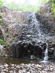
The trail continues pleasantly around the top of the "mountain" to Hemlock Falls, pictured above. This is the midpoint of the trip and a nice spot for lunch. You can take a set of stairs above the falls, although there is nothing spectacular up there.

The return follows the Rahway "River" (more of a creek, really). The trails widens and eases up, but don't think the return trip will just be a trudge. The river widens into a pond and just after that is an abandoned pumphouse.
Buildings like this are usually sensibly locked up so no one hurts themselves and sues. Not this time! I was squeeing with glee to discover it was open and I could wander around, trying not to fall through the rotting floor, to my heart's content.
After that is an old bridge shored up enough for pedestrians, then a dam. Not long after, you end up where you started.
On the weekends, trains run from Penn Station once an hour, so you have to time it carefully (and note that fare is $8 each way). The vehicularly endowed can choose to drive, of course. Either way, this hike is a genuine hike that takes full advantage of the land it is sited on.
The 5.2-mile loop hike is easily accessible via NJ Transit, and it's a good one for novice hikers. The hardest part occurs straight out of the gate, when you have to head uphill on the Lenape Trail. Survive that, and the first major reward is an overlook of Millburn. The overlook is probably much better in winter, but there are two interesting markers at the spot: One for where George Washington supposedly stood, and a rather enigmatic memorial to a friend of the park.
The trail continues pleasantly around the top of the "mountain" to Hemlock Falls, pictured above. This is the midpoint of the trip and a nice spot for lunch. You can take a set of stairs above the falls, although there is nothing spectacular up there.
The return follows the Rahway "River" (more of a creek, really). The trails widens and eases up, but don't think the return trip will just be a trudge. The river widens into a pond and just after that is an abandoned pumphouse.
Buildings like this are usually sensibly locked up so no one hurts themselves and sues. Not this time! I was squeeing with glee to discover it was open and I could wander around, trying not to fall through the rotting floor, to my heart's content.
After that is an old bridge shored up enough for pedestrians, then a dam. Not long after, you end up where you started.
On the weekends, trains run from Penn Station once an hour, so you have to time it carefully (and note that fare is $8 each way). The vehicularly endowed can choose to drive, of course. Either way, this hike is a genuine hike that takes full advantage of the land it is sited on.
Friday, June 8, 2012
There but for the grace of dog
I wasn't a fan of this blog post on telling would-be grad students not to go to grad school, because I think it unfairly conflates giving realistic advice with victim-blaming. But I did like this quote:
"What, prey tell, are those would-be English PhDs supposed to do? Journalism? Ha! We know they can’t do law school! Publishing? Not even worth joking about. Secondary school teaching? Not now, after NCLB/Michele Rhee/budget cuts/TFA/Scott Walker have all had a go at teachers."
Not that long ago, it was generally agreed upon that if someone had a college degree and was even marginally able to get along in society, they'd be able to make a decent living. There was no guarantee of riches, but you'd be able to own a car, eventually buy a home (at least if you didn't live in New York), and have kids. Now, even The New York Times recognizes that only half of college grads are finding jobs that require a diploma.*
What about the traditional professions - law, medicine, clergy?
This morning, Inside Higher Ed reports on the dismal job market for law school graduates. The market for clergy is even worse -
two graduates for every position, although there are positions open because the churches are tiny and can't afford to pay anyone. Physicians are actually doing all right, although there are fewer rich-doctor positions than there were in the past.
You might say, in that case, forget college. Before you do that, look at this chart.
So you can be a doctor, and there are still jobs in the sciences. Of course, while it might work for any one person to go into those fields, they can hardly absorb the entire supply of unemployed and underemployed Americans.
In this environment, it might make as good economic sense as anything else for a young person in need of work to say, "I'm chucking it all and surfing in Bali." At least, that is, if they don't have student loans. Or, "I'm going to go Occupy Wall Street." **
We're in a new era of constant insecurity, so anyone who tells a young person, "It's your own fault for going into creative writing/law/whatever," should be whacked with a large stick and summarily stuffed into an anti-aging machine to be forced back to the age of 18. And if that's not enough to depress you, go here.
Something is going to have to give, but I don't know if it's going to be Occupy grown large, the education credential bubble bursting, or a crisis of consumer confidence.
* Let's ignore, for the moment, the shakiness of defining jobs that "require" a college degree, and let's just assume that jobs that ask for them actually do require skills learned in college.
** Except, interestingly, for this generation there doesn't seem to be the kind of generation gap that would fuel protest. That's a whole other other post.
Sunday, June 3, 2012
Pelham Bay Park hike
Executive summary: There are three reasons one might do this hike. One, you want to prove once and for all that you are impervious to poison ivy. Two, an eccentric billionaire will pay you $1 million to complete every hike in AMC's Best Day Hikes Near New York City. Three, someone you loathe with every fiber of your being has been begging you to take them on their first hike.
Full report: Since I spent part of Saturday volunteering at Van Cortlandt Park, I figured I should make it a Bronx weekend by doing a hike up at Pelham Bay Park. Granted, it would be short, but it made the cut in the Best Day Hikes book, whereas nothing at Van Cortlandt did - and I thought Van Cortlandt was rather scenic.
I made the mistake of following the book's instructions to the park instead of Google Maps'. The Bee-Line 45 did not stop at the park as I had been promised, and I had to get off a mile later and walk. This ended up not being as bad as I expected (no sidewalks, busy road), as I was able to pick up an unnamed trail until I got the trail I was aiming for. As a horse trail, it had muddy spots, but surprisingly few horse poops.
The Siwanoy Trail was utterly wretched. It was incredibly overgrown, so it was less of a hike and more of a game of Dodge That Plant. Many of those plants were poison ivy. It is evident that maintenance has not been done in a long time, and the trail is not worth hiking until it has. Amazingly, I saw four other hikers, none of whom looked as if they were enjoying themselves.
The highlights of the scenery are the views of the lagoon and marshes, but you could see those instead by driving to the Bartow-Pell Mansion and strolling around the grounds. I did pop by for a free carriage house tour (the main house costs $5). The trail itself is flat and, as I may have mentioned, a slog.
I did end up skipping out on a brief bit of the trail, as it didn't look any better and the weather was getting worse. I decided to follow Google Maps out, which made me walk a mile away from the park in the opposite direction, which thankfully had bike and horse paths. It also started raining. Have I mentioned my allergies were acting up, too?
The hike, in sum, was a real bust. If for some reason you do feel compelled to hike at Pelham Bay Park, stick to the other trails. I don't know if they're good, but they can't be worse.
Subscribe to:
Posts (Atom)