Thursday, December 31, 2020

Sterling Forest Fire Tower

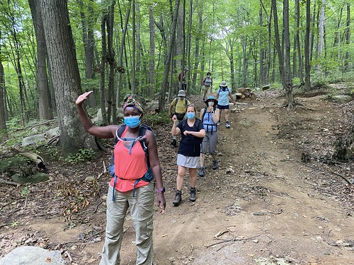
On my last day with a car, I met K at Sterling Forest State Park to hike to the fire tower there. The hike is, according to the visitors center, four miles round-trip, but the NY/NJ Trail Conference maps show it as slightly longer.

We followed the recommended route, which forms a lollipop loop. The return loop, on the red trail, is an old road and much easier, and if I had known that, I might have guided us to use that for both ways. But instead we took the more challenging trail up.

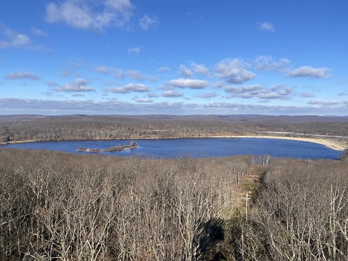
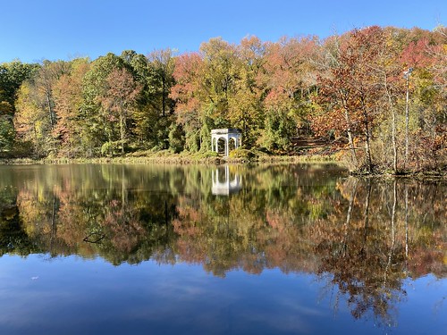
Either way, at the beginning we passed by the old ironworks and then Sterling Lake, both interesting and scenic. 

Sterling Forest tower

The tower itself was closed - not just the cab, but the stairs too. So no vistas, and I'll have to return to climb it. But it was still a nice hike, and good company!

Sterling Forest tower

Wednesday, December 30, 2020

Jackie Jones fire tower

I've spent lots of time in Harriman since moving to New York, but some corners of it are harder to reach via public transit. This includes the area around Lake Welch on the southeastern side of the park. I have passed through before - at least once, when I did the SBM end-to-end, but I haven't explored much. 

In fact, I even violated my rule of "never pass up a fire tower" when doing the SBM! So I wanted to visit the fire tower. I also wanted to see St. John's-in-the-Wilderness, a small church that my hiking club has visited, but I've never made those trips.

Jackie Jones & St. John's

Starting from the parking area at 106, I headed south on the Suffern-Bear Mountain trail. The water was really high, with a lot of ice, and there were a few dicey stream crossings. After passing the Orak ruins, I approached Jackie Jones Mountain. A large radio tower is actually visible before the fire tower.

Jackie Jones & St. John's

The tower was open, even the cab, so I enjoyed the views (not so much the graffiti) before continuing on. I passed Big Hill shelter, where a hiking club was setting up lunch, then turned onto the Long Path. There is a memorial to a flight that crashed.

I didn't so much miss the turnoff to the chapel as I missed the turn the main trail took to avoid the turnoff, which worked out just fine. The chapel was cute from the outside.

St. John's in the Wilderness

From there I followed the road (very low traffic) to the paths around Lake Welch. The sandy beach was closed for the season. Then it was back into the woods to catch a short bit of the SBM back to the parking area.


Lake Welch

Tuesday, December 29, 2020

Visiting Tallman Mountain

I wanted to find a hike that was a relatively short drive (yes, I had a car, briefly!) that I couldn't easily get to via public transit. Tallman Mountain sort of fit the bill. One can get there via bus, but I don't think I ever have. Also, it wasn't an area written up in either of my local hiking guides. Was it dreadful? Well, it's in the Palisades, so it has to be at least okay ... but you're already on top of a cliff, so how is there a mountain?

It turned out to be perfectly pleasant. The Long Trail runs through the park, as it does along the entire Palisades. That, along with a bike path, forms a decent loop. The mountain comes in because the Palisades have a break where Sparkill Creek enters the Hudson. On its south side, Tallman "mountain" just seems like a minor hill, but its north face heads steeply down to the water. 

Tallman State Park
As always in the Palisades, there are views off to the east of the Hudson, although this section is somewhat lower in elevation. There is also a marsh here along the western shore, which is visible through the trees as well. 
Tallman State Park

Overlook Mountain and new trails

On my final day in the Catskills, I opted to do a repeat hike that is just fun - Overlook Fire Tower. It's one of the most popular hikes in the Catskills, so the trail would be broken. Plus, the hike is on a gravel road, so while it's uphill the entire way, the terrain isn't difficult.

Because it is so popular, a second parking lot has been built down the road, with a connecting trail and two side loops added. These I had not yet done.

Despite not getting an alpine start, I saw only a few people on the trail when I set out. I stopped at the ruins before proceeding to the tower. Two women and a dog were at the overlook, but no one else was at the top of the mountain, so I climbed the tower.

Overlook Mountain

On the descent, many more people were streaming up the hill. But when I turned off to the access trail, the people disappeared.

These new trails were peaceful and enjoyable, but they don't go to any vistas or natural sites of interest. They're just a nice walk in the woods. 

Overlook Mountain

From there, it was home again, because a storm was due to come in that night. I just thought it would make for bad hiking, but it turned out to be devastating. It was rain, not snow, and it melted all the snow on the ground, causing massive flooding. This, in turn, caused major infrastructure damage.

Monday, December 28, 2020

Up Dutcher Notch

Due to anxiety about driving on black ice, I skipped doing a 3500 peak my second day in the Catskills in favor of a trail that was close to my motel. I needed to hit Dutcher Notch eventually for the all-trails patch, anyway.

Dutcher Notch is a steep climb up to the Escarpment Trail. One could use it as a way to reach Blackhead, but it's not the easiest approach to it, so it gets less use than some other trails. This meant I needed to break out my snowshoes. It wasn't virgin snow, but it wasn't packed, either.

Dutcher Notch

It also doesn't have any particular views, which was fine on a gloomy, gray day.

Although only 1.9 miles, this hike pointed out how out of shape I am, thanks to 1,400 feet of elevation gain, plus the additional challenge of snowshoes. But since I was alone, I could hike as slow as needed!

As I approached the Escarpment Trail, there was a nice view of Blackhead (in the summer it would be obscured by the trees). 

Blackhead Mountain

The other thing this hike had was solitude - I encountered no other hikers on it that day.

Two easy Catskills hikes

I spent three days in the Catskills. Originally intended to be a week, I changed my plans for various reasons that proved fortuitous when a major storm wreaked havoc on the area the evening I left.

On the day I drove up, I broke up the drive with a stop at Onteora Lake. There are three trails there that are a part of the all-Catskills trail challenge, so I wanted to visit them. In the end, I didn't - I got distracted by the other loop trails, which I guess don't count as they are for mountain biking, maybe? 

Onteora Lake

The trail is quite popular, as it's near Kingston, relatively flat, and has excellent lake views, so no spikes or snowshoes were needed. The views of the lake, which come at the beginning of the hike, were excellent. The rest of the hike was through attractive woods.

I had hoped to do a second hike that afternoon, but the parking lot and driveway weren't sufficiently plowed, so on a whim I parked at nearby Olive Bridge dam. Honestly, it wasn't even clear to me that it was anything other than a parking lot, but there were other cars, and what looked like a view, so ...

The dam is the major one at the Ashokan Reservoir, and the top of it is open to pedestrians. Of course, it is flat and paved, and probably only a mile long. However, the views of the dam are spectacular.

Olive Bridge dam

Wednesday, December 23, 2020

Walking from VCP

This month I was faced with the conundrum of getting to Van Cortlandt Park to do my trail maintenance but not feeling comfortable on the subway. I had learned last month that Metro North felt reasonably safe, and was better about masking. It's also a shorter ride - about 20 minutes - but with a two-mile walk to the station at this end, and a mile and a half from the station to the park* (7 total, round-trip). So, I was curious about the feasibility of walking.

It's 7 miles to the park, 14 miles round-trip. But these are the short days of winter. And with any of these options, I had to walk in the park, too. I opted to compromise: Take Metro North up in the morning, when it is pretty empty, and walk back. 


Palisades
*This is coming in from the Hudson line, west of the park; it's actually shorter to come in from the east on the Harlem line.

Saturday, November 28, 2020

The long way to an underground creek

I wanted to check out what looked like the remains of a creek on Google Maps, so this walk was highly exploratory.

It began with a walk to Randalls Island, and under Hell Gate Bridge to the Bronx. This is a longer route than using city streets, but a more scenic one.

Randalls Island

From there, I headed north, past St. Mary's Park, to where Westchester Road crosses a narrow channel of what used to be a creekbed. It seems to be the only visible remainder of the now-underground Mill Creek. (You can read more at the Hidden Waters blog.)

Mill Brook

I took the more efficient return route, via the Third Avenue Bridge. 

Rambling in Central Park

As part of my quest to visit all the Manhattan pedestrian bridges, I had to visit Central Park's Ramble for a mop-up. While I spend less time in the Ramble than in the more northerly parts of the park, I was pretty sure I'd been to each bridge. I just didn't have proof.

The first bridge of note is Triplets Bridge, which is actually west of the Ramble. It's over a gully to the side of the Lake, which may dry up at times. From there it was over Oak Bridge and into the Ramble itself.

Triplet Bridge

Unlike the Ravine, it's easy to visit each bridge in the Ramble linearly, with no doubling back. The bridges are as follows:

Gill bridge, a rustic bridge - like two rising suns.

Gill bridge

An ignored bridge at the top of a cascade.

Gill bridges

A rustic bridge - with Xs.

Gill bridges

A tiny rustic bridge.

Gill bridges

An ignored, tiny stone slab bridge.

Gill bridges

From there, I strolled around the rest of the Lake, enjoying unseasonably warm November weather.

Bow Bridge

Sunday, November 22, 2020

VCP a new way

To be accurate, I didn't get to Van Cortlandt Park a new way, just back from it. I've found that the subway early on a weekend morning is fine. But coming home later in the day, it's more crowded. And there are always multiple people - in every car - not wearing a mask. 

Van Cortlandt Park

So I took the 1 train up to VCP and hiked to my trail section, which is at the northern end of the park. Afterwards, though, I walked out the northeast corner and over to the Wakefield Metro-North station. The Harlem line train is twice as fast as the subway, and thanks to the conductors, people are all masked. The two downsides are that it costs a bit more ($4.50 more), and that the closest stop is still two miles from my place. I can afford the cost, but not everyone can.

It was a beautiful day, weather-wise; I was in a t-shirt (in November!). After the park, which was its usual nice self, I wanted to visit the Wakefield Ave. bridge. It's one of the few pedestrian-accessible bridges that crosses out of NYC - in this case, along the very messy portion of the Bronx-Yonkers border. The border follows the former course of the Bronx River here, rather than its present one. 

The bridge itself is long, spanning the river, a parkway, and multiple railroad tracks, but not particularly interesting. The Bronx River as it passes under is inaccessible here, trapped between the parkway and the MTA tracks. But it (quite conveniently for my purposes) has a pedestrian staircase down to the Wakefield train station.

  Wakefield Ave. bridge

Hiking to Queens

 I took the Triborough over to Randall's Island and then to Queens.

RFK Triborough Hell Gate

Sunday, November 8, 2020

Tibbetts Brook adventure

These days, going as far afield as Yonkers is an adventure - when even travel to New Jersey that is "non-essential" is frowned upon. But I had to venture up to Van Cortlandt Park to do my trail maintenance, and I wanted to see the newly paved Putnam Trail. One thing led to another, and I walked around the lake at Tibbetts Brook before heading back into VCP to do the work.

Putnam trail Tibbetts Brook Park

Sunday, October 11, 2020

Visiting Washington and 145th St. Bridges

Washington Bridge was another bridge I was pretty sure I'd been to, but I couldn't prove it. (Eventually, I did dig up an Instagram post proving I was there three years ago.) And I knew for sure that the 145th St. Bridge was the final Manhattan-Bronx bridge I hadn't yet visited. So I headed uptown to see them both.

Washington Bridge is more interesting from below than from on it; it needs some TLC. You can get some nice views from it, particularly to the north. 

Washington Bridge

145th St. Bridge is kind of cute.

145th St. Bridge

Woodlawn Cemetery

Despite its location right next to Van Cortlandt Park, I'd never been to Woodlawn Cemetery. It's actually quite a walk from the 1 train, which is how I get up there. But at our most recent Trails Crew day, we were working on the east side of the park, so I took advantage of this to tack on a visit to the cemetery.

Woodlawn Cemetery

I only saw a small part of it. Add up long walks at both ends of the train ride, plus a day of trail work, and I only had so much energy for exploring what is a very large area.

Woodlawn Cemetery

But it's impressive. Do you like tombs? They have tombs. Also gravestones, monuments, and a nice little lake.

Woodlawn Cemetery

Sunday, September 27, 2020

Randalls and Wards Island, west side tour

Yesterday's hike didn't cover any new territory, but I went places I hadn't been in a while, even on my previous trip to Randalls Island.

Salt marsh bridge

After walking across Manhattan and over the pedestrian bridge, I headed north up the west side of the island. This took me up a gravel path with views of Manhattan to the salt marsh. There is a small bridge here and a wetland. After this, I continued on to a good view of the Triborough bridge East River span.

RFK over the East River

The north part of the island is mostly athletic fields. I followed along the edge of the Bronx Kill, a small creek separating Randalls Island (which is legally part of Manhattan) from the Bronx. The path crosses under the Triborough Bronx Kill span and then under the Amtrak railway bridge. Under this is a tiny pedestrian bridge to the Bronx. While I'd been here before, I didn't have any good photos of it.

Bronx Kill connector

I returned to the RFK and walked up the pedestrian crossing to the Bronx, then back to the island. From there, I essentially retraced my steps the rest of the way.

Beach view of Manhattan

Monday, September 21, 2020

Across University Heights Bridge

I thought that the University Heights Bridge was one of four remaining Bronx-Manhattan bridges I had not crossed, so I took an after-work jaunt up there - only to discover I had been there previously with my hiking club. This time, though, I got some better pictures of it.

University Heights Bridge

On approach from Manhattan, you really can't get a good look at it. (From the Bronx, the view is better.) But here's a close-up of the little covered pavilions, which are charming.

University Heights Bridge

The walkway is only on the southern side of the bridge, and there are some nice views of the Harlem River.

University Heights Bridge

From the bridge, I decided to head down the east side on the greenway, which was a mistake inasmuch as it's a trap - once you enter at Dyckman Street, there are very few exits. It's not particularly well lit, and it is used by bicycles; I didn't fancy a collision. But I did exit at the Bushman Steps before dark. Along the way the Harlem flows into the East River and I passed under Washington Bridge, I-95, and High Bridge.

Three bridges

Wednesday, September 16, 2020

Van Cortlandt, again

Van Cortlandt Park

On Saturday, I headed up to Van Cortlandt to do my trail maintenance. The hike wasn't particularly exciting in and of itself, although I did check out the improved entrance at the southwest corner, which I never walk by.

Saturday, September 5, 2020

Bridges of the Bronx River

I'm currently on a quest to visit pedestrian bridges in New York City, so last weekend I headed up to the Bronx to walk most of the bridges that cross the Bronx River in the Bronx. 

Nereid Ave.

The border between the Bronx and Westchester is a bit jagged at the river, but the first bridge is at Nereid Ave. So I started there, walking back and forth between the east and west banks, sometimes walking along greenways, sometimes using sidewalks. (However, at the botanical gardens and zoo, I went around; it'll take a separate visit with admissions fees to visit those bridges.) 

174th St. bridge

Bridges include roadway bridges with sidewalks as well as pedestrian-only paths. There are other crossings, including rail and parkways, but those don't allow foot traffic. 

Bronx River

While this isn't the best way to see the river - that would be the Bronx River Greenway - I saw plenty of it, ranging from glimpses of it to expansive views. As it wends south towards the East River, it gets wider. Rather than stopping at the final bridge, I elected to head into Soundview Park and follow it to the end of the river. 

Bronx River

From there, it was a bit of a haul back to a convenient subway stop, so all told I hiked over 18 miles. 

E. 233rd Bridge

Wednesday, August 26, 2020

Ringwood State Park adventure

Some hikes are cursed, and it takes several tries to break the curse. 

In March, we scouted for a hike I was supposed to lead in April. On that scout, we learned that the hike description was a little too ambitious, but that was fine. I fine-tuned it.

Then, of course, the April hike was cancelled.

But we put it back on the schedule for August, thinking things would be somewhat normal by then. Ha! The bus the hike relies on is still not back in service.

So, a hike in the same general area was substituted. But I do mean "general" - there wasn't going to be any real overlap with the original hike. I had a vague plan in mind, which unfortunately had a good deal of roadwalking at both ends - the bus stop just isn't near the park.

Sunday turned out to be hot and humid, so on the fly we agreed to stick to more old woods roads and less hilly trail. But first we had to get into Ringwood State Park.

Ramapo Lakes and Ponds
Rather than follow my planned road walk, we tried a woods shortcut suggested by another Rambler. However, we got turned around, so ended up road walking anyway. Fortunately, these were well-shaded, quiet suburban roads. 

Ramapo Lakes and Ponds
Once in the woods, it was a challenge to follow the old roads - and the correct old ones, since the map doesn't show them all. We ended up going to the botanical gardens, although we had less time to explore them than I would have liked.

On the return, we did find the shortcut, so now I know where it is.