Saturday, November 28, 2020

The long way to an underground creek

I wanted to check out what looked like the remains of a creek on Google Maps, so this walk was highly exploratory.

It began with a walk to Randalls Island, and under Hell Gate Bridge to the Bronx. This is a longer route than using city streets, but a more scenic one.

Randalls Island

From there, I headed north, past St. Mary's Park, to where Westchester Road crosses a narrow channel of what used to be a creekbed. It seems to be the only visible remainder of the now-underground Mill Creek. (You can read more at the Hidden Waters blog.)

Mill Brook

I took the more efficient return route, via the Third Avenue Bridge. 

Rambling in Central Park

As part of my quest to visit all the Manhattan pedestrian bridges, I had to visit Central Park's Ramble for a mop-up. While I spend less time in the Ramble than in the more northerly parts of the park, I was pretty sure I'd been to each bridge. I just didn't have proof.

The first bridge of note is Triplets Bridge, which is actually west of the Ramble. It's over a gully to the side of the Lake, which may dry up at times. From there it was over Oak Bridge and into the Ramble itself.

Triplet Bridge

Unlike the Ravine, it's easy to visit each bridge in the Ramble linearly, with no doubling back. The bridges are as follows:

Gill bridge, a rustic bridge - like two rising suns.

Gill bridge

An ignored bridge at the top of a cascade.

Gill bridges

A rustic bridge - with Xs.

Gill bridges

A tiny rustic bridge.

Gill bridges

An ignored, tiny stone slab bridge.

Gill bridges

From there, I strolled around the rest of the Lake, enjoying unseasonably warm November weather.

Bow Bridge

Sunday, November 22, 2020

VCP a new way

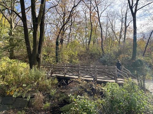
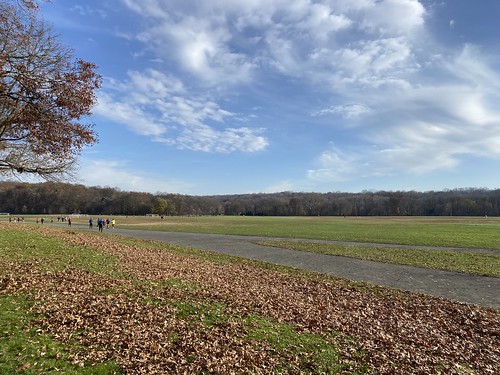
To be accurate, I didn't get to Van Cortlandt Park a new way, just back from it. I've found that the subway early on a weekend morning is fine. But coming home later in the day, it's more crowded. And there are always multiple people - in every car - not wearing a mask. 

Van Cortlandt Park

So I took the 1 train up to VCP and hiked to my trail section, which is at the northern end of the park. Afterwards, though, I walked out the northeast corner and over to the Wakefield Metro-North station. The Harlem line train is twice as fast as the subway, and thanks to the conductors, people are all masked. The two downsides are that it costs a bit more ($4.50 more), and that the closest stop is still two miles from my place. I can afford the cost, but not everyone can.

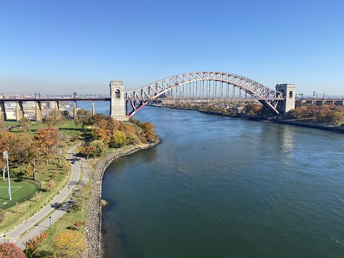
It was a beautiful day, weather-wise; I was in a t-shirt (in November!). After the park, which was its usual nice self, I wanted to visit the Wakefield Ave. bridge. It's one of the few pedestrian-accessible bridges that crosses out of NYC - in this case, along the very messy portion of the Bronx-Yonkers border. The border follows the former course of the Bronx River here, rather than its present one. 

The bridge itself is long, spanning the river, a parkway, and multiple railroad tracks, but not particularly interesting. The Bronx River as it passes under is inaccessible here, trapped between the parkway and the MTA tracks. But it (quite conveniently for my purposes) has a pedestrian staircase down to the Wakefield train station.

  Wakefield Ave. bridge

Hiking to Queens

 I took the Triborough over to Randall's Island and then to Queens.

RFK Triborough Hell Gate

Sunday, November 8, 2020

Tibbetts Brook adventure

These days, going as far afield as Yonkers is an adventure - when even travel to New Jersey that is "non-essential" is frowned upon. But I had to venture up to Van Cortlandt Park to do my trail maintenance, and I wanted to see the newly paved Putnam Trail. One thing led to another, and I walked around the lake at Tibbetts Brook before heading back into VCP to do the work.

Putnam trail Tibbetts Brook Park