Monday, June 30, 2014

Fahnestock State Park hike

Canopus and LaurelI spent my last day at Fahnestock State Park, about halfway between the city and the Catskills. My body was tired, so I spent Wednesday morning doing an easy hike, just 2.3 miles each way on the Appalachian Trail. The hike ended with a view of Canopus Lake, which was nice, but the real highlight was the mountain laurel, which peaks at the end of June. I could hardly pass that up.

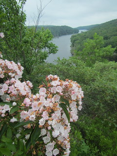
The surprise here was how nice the campground was. I had a really pretty site, but all the sites were attractive. There are bathhouses (although my shower was cold), a nature center, a lake with a beach and rowboats for rent, as well as a pond. The pond was much prettier than the lake, and I ate lunch there before heading home. It would be a nice park for a weekend getaway from New York city, especially if the entire group wasn't rabid hikers.

Sunday, June 29, 2014

Twin and Indian Head hike

"Trail"Finally, a double-header!

Twin and Indian Head are pretty close, so doing both in one day seemed entirely possible. The easiest way to reach both is to head up the Jimmy Dolan Notch trail, which meets the Devil's Path with Twin one way, Indian Head the other. The photo at left is on the Jimmy Dolan Notch trail - please note that the path goes up and over that tree and boulder, not around it. At the notch (apparently the local word for a small valley between peaks) there is a nice view, but it was breezy and too early for lunch.

I started with Twin. Twin has an east summit before the real summit (hence the name, one would assume). Both have views, although the view from the east summit is better. That's what you see below. Note the clouds rolling in. The actual summit isn't much farther along.

Twin east summit So I started back down to the notch, and on the way down it began misting. It looked as if I might have to call off Indian Head, because slippery rocks are no fun. The mist stopped, though, so I headed up to Indian Head.

There is no view from the top of Indian Head. That didn't really matter, though, because fog had rolled in and I wouldn't have been able to see anything anyway.

Indian Head didn't have a clearly visible summit, or, like West Kill, a cairn. The top of the mountain is a long ridge, and after a certain point it becomes obvious you are going downhill. A little anti-climactic.

After returning to my car, I drove to nearby Plattekill Falls, which is basically right off the road.

I was supposed to stay another two nights, but the weather forecast was grim - 80 percent chance of rain the next day, so I decided to move out.

Saturday, June 28, 2014

Mount Tremper fire tower hike

Fire towerOn Monday, I thought I'd take it easier and do a shorter hike than I had originally planned. Besides, after seeing Hunter's fire tower, I had added "doing the fire towers" to my to-do list (yes, there is a patch).

The tower itself was closed, it being a weekday, but the stairs were open. However, the view from the top wasn't as impressive. The area around Hunter's tower is cleared, but not around Tremper's. The highlight of my trip came on the way back down. I was tromping downhill like a herd of elephants, as I'm wont to do when wearing boots, when there was a rustling noise up ahead. And there, behold, was a porcupine. It looked at me, I looked at it, and after I backed up a little farther it trundled off into the woods. Perhaps I was unreasonably excited by this, as I don't think they're rare or unusual, but I'd never seen a porcupine in its natural setting before.

Porcupine

Friday, June 27, 2014

West Kill hike

Diamond Notch FallsSince I hadn't made it up West Kill the previous day, I was determined to bag it the next day. I didn't want to head up the same route, though - an equal mix of wanting to see a different trail and not looking forward to that steep climb at the beginning. Instead, I drove to the Diamond Notch trailhead to begin.

The actual, official trailhead is only accessible by car if you have a Jeep or similar vehicle; the road turns from pavement to nice smooth gravel you'd be happy to bring home to your mother, before abruptly narrowing to two rocky ruts. Luckily, there is parking at this spot, too, not just at the official start.

Buck Ridge lookoutDiamond Notch proved to be an excellent choice, however, as the trail goes up to Diamond Notch Falls. From there, one has to get back on the Devil's Path and keep going up. The top of West Kill doesn't have a view; you only know you've arrive by the rock cairn. However, very close to the summit is the Buck Ridge lookout, with views in two directions, which is where this second shot was taken.

The only negative on this hike was the outlandish number of flies. (It is the Devil's Path; I suppose this part is devoted to Beelzebub.) One-way, this hike was 4.5 miles, which doesn't sound like much, but again it was steep.

Thursday, June 26, 2014

Hunter Mountain hike

Yes, it's trailOn Saturday, I began my assault on the Catskills 3500s. Perhaps "assault" is overstating the case a little, though. Think more of trying to slice bread with a foam noodle.

The photo to the left shows a typical bit of Catskills trail. This bit, at least, is mostly walking - no clambering over boulders. Pretty much everything, though, is rocky and steep. The Devil's Path on the way up to Hunter gains about 800 feet of elevation in maybe half a mile before leveling out to something slightly saner. At a junction, the Spruceton trail heads north the Hunter and the Devil's Path continues on to West Kill. I followed the path to Hunter.

Hunter was an excellent choice for a Saturday, as on summer weekends the tower is staffed by volunteer stewards. John and Ralph were manning the tower (that's Ralph down there in the chair; John was up in the tower). They open the room at the top of the tower as well as provide general knowledge, such as what peak is what. There are five fire towers in the Catskills, so with Hunter I was knocking off a 3500 and a tower.

Fire tower cabinThe view from the top of Hunter was magnificent, of course.

By this time it was clear to me that I wouldn't make it to West Kill in any sane manner. It's possible, of course, if one gets started earlier in the day than I did, and is in better shape than I am. Nevertheless, there was no rush to get back down. So I walked over to the Colonel's Chair, which is the top of the Hunter Mountain ski resort.

Rather than closing up in the summer, the resort has a few warm-weather activities such as a challenge course - and the Sky Lift. The lift is free to ride down - $11 to go up. I figured I might as well do it while I was in the neighborhood. The ride was worth it for the views. So I rode it down and up, and then headed back down the mountain. Oh, and how steep? The hike was 5.85 miles one-way, with 3762 feet of elevation gain over the round trip (not including the ride up the lift).
SkyLift

Kaaterskill Falls

Bastion FallsI spent almost a week in the northern Catskills, recovering from the end of the year/batizado/guests/finishing the book, and it was incredibly beautiful as well as therapeutic. It was also some hard hiking.

When I arrived on Friday, it was already mid-afternoon, so I decided to take in a scenic hotspot with a decent effort:reward ratio: Kaaterskill Falls. It's a hike of just half a mile, which makes it very popular.

There is no parking at the trailhead, so you have to fight for a spot in the small parking lot and walk along the shoulder of highway 23A. Luckily, the speed limit is very low - 20 mph around the final curve. The trail starts off with Bastion Falls, pictured above. Bastion Falls is visible from the road, and it says something about the local scenery that they felt it was worth running the road past but not worth making a pull-off for tourists to gape at it from. 

Kaaterskill FallsFrom there, the trail is "only" half a mile to the main event, but quite rugged and steep. Most people who aren't mobility-impaired would be able to do it, as long as they take their time. From Kaaterskill, an unofficial trail heads up to the top of the falls, but I did not take it. Kaaterskill Falls, at left, was impressive enough.

I should mention that my ambition for the trip was to knock off several Catskills 3500 peaks. There are 35, and I wanted to do as many of the peaks with trails this summer as I could. My plan for the next day was to start off with Hunter and West Kill, both of which can be accessed by going west on the Devil's Path from the campground I was staying at. I didn't count on how rugged the Catskills were actually going to be!