Over the weekend I went on a two-day backpacking trip to Laurel-Snow on the Cumberland Trail. It was a good trip, although I have a few cautions for anyone else who wants to do it.
The website doesn't provide a step-by-step description of the trail, as it does for most of the segments. We were using a Mountaineers trail guide from 2000, and it is outdated. So if you go, rely on the CTC map - but better yet, take someone who has done it before with you.
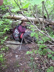
The trail is straightforward up to a junction 1.5 miles in. From there, Snow Falls is to the left and Laurel Falls is to the right. If you go left, very shortly there will be a campsite on your left. (It's not shown on the map.) We spent the night there. Our intent had been to set up our tents and then hike up to Snow, but a rainstorm postponed it until day two - which was for the best, because the hike took us much longer than we had anticipated given the mileage.
The hike to Snow is nice; it has some uphills and rocks. We did have to cross Morgan Creek, and it was a wet crossing, not long before the falls. The problem is the trail ends at the top of Snow Falls. If you want to see the falls you have to scramble off trail through a lot of poison ivy. It's worth it, but I wouldn't do it with little kids or a big group. There is another campsite here as well.
To get to Laurel Falls, return to the split and take the right fork. Immediately you are confronted with an obstacle: a tree has fallen on the path - not parallel to it but directly on it. The trail is between two boulders at that point, so it's a long way around. From there the trail is relatively clear to the base of Laurel Falls.
The way up to Laurel Falls is not clear. (Signage is generally unclear; in particular, watch out for turns that are not marked with double blazes.) You have to backtrack maybe 100 feet and head uphill. The route quickly becomes scrambling. At the top, the trail takes a turn for the worse. Although you're on the plateau, so the going should be easy, there are a whole lot of trees down. (Pine beetle problems?) This also means that blazes are down. We finally wandered over to Laurel Creek, right where it plunges over the edge, but we couldn't find the main trail. We had already ditched our packs because they were making tree limbo difficult.
Despite the challenges, we had a good time. The trail does need some maintenance, and I wouldn't go if you have small kids or aren't familiar with trail conventions. The map could use more detail, such as the locations of campsites, and the website needs more detail and clarity. (For example, the text states that Dunn Point is also known as Buzzard Point, but they're shown as separate locations on the map.) The trail is maintained by volunteers (I'm one), and this looks like an area that's due for some work.
1 comment:
I grew up 20 minutes away from there and Hike / camp there all the time. The two best camp spots are 1) left of Laurel Falls right along the cliff side (camp site stays dry if it rains), and 2) on top of the cliff, after you cross Laurel, at the overlook (I'd go in the fall/winter/spring when the snakes aren't out).
Post a Comment