 Breakneck Ridge is one of the major hikes in the NYC area. The view of Storm King from Breakneck is featured on the covers of both of my area hiking guides, and, supposedly, Trails.com chose it as one of their 10 best day hikes in the country, which is a bold claim for anything around here. I finally decided to do it on my own.
My planned route would take me from the Breakneck Ridge stop on the Metro North line, up Breakneck, and back down via the Undercliff trail. Apparently, the Thing To Do if you are a Real Hiker* is to go along the ridge to the fire tower. On my first trip up there, solo, out of shape, and with a bum shoulder, I decided merely to reach the ridge.
If you take the train, you might as well hike with a group; about 20 people exited the train and started up the mountain at the same time with me. If you really want solitude, drive, be super-fast, or hang back for a half hour. However, I doubt you'll ever find true solitude anywhere on these trails.
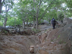 After the short road walk, the trail starts off gentle for, oh, five feet, before turning into a scramble. It takes all four limbs to get up 700 feet in half a mile, nearly all of it pure rock. I probably shouldn't climb boulders with my shoulder, but I threw caution to the slight breeze and headed up, albeit carefully. This was the hardest part of the hike, but I imagine it would be even harder coming down if you elected to return the same way.
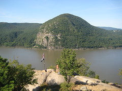 Breakneck is on the east side of the Hudson, and I soon had Storm King photos of my own. This area was the home base of the Hudson River School, and there are at least four HRS paintings of Storm King. This painting by Pope is probably my favorite. One thing you'll notice in any of the paintings that also depict the river: There were a lot more boats plying the Hudson back in the day.
From Breakneck you can also see Bannerman Island with its ruined mansion. Supposedly, it was destroyed by fire, but I prefer to think it was taken down by HULK SMASH.
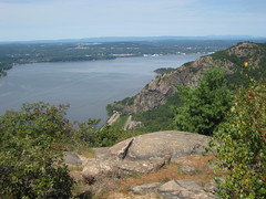 After following the white-blazed Breakneck Ridge trail up to more or less the top, I turned down the blue trail and onto the red. This section doesn't have any amazing views, although it does have the ruins of a dairy. My brief excursion on the red trail did have a nice brook running by it. I joined the Undercliff trail (having missed the part of it that was actually under a cliff), following it to a junction with the white trail that led down to the town of Cold Spring. This photo is taken from one of the few scenic vantage points facing the Hudson on the Undercliff. For perspective, the trail started just on the other side of those tunnels. This section of trail isn't as interesting, and I was surprised to see a lot of people starting to come up it in the early afternoon.
I finished by wandering across the highway to Little Stony Point, which was almost entirely devoid of interest, and into Cold Spring. For my Oregon friends, Cold Spring is the New York version of Jacksonville. It's an hour from the city, very quaint, and not at all cheap. I couldn't afford a house, so I bought an ice cream cone instead.
The hike was undoubtedly the nicest I've done in the region so far, but one of the ten best in the country? That rating is probably due in part to its proximity to a major urban area. I doubt many people have sufficient day-hiking experience all over the country to really compare-and-contrast. One other note: My hiking guide rated a shorter version of this hike, 5.9 miles long, as taking seven hours. I went about eight miles in four hours, and I don't like to hike fast when I'm going alone. I passed a few novices and large groups, but plenty of folks were zipping by me.
*Some people use scare quotes; I go German with my capitalization.
No comments:
Post a Comment