 Well, I finally did the Suffern-Bear Mountain End-to-End hike. Put on annually by the Appalachian Mountain Club, this hike travels the entire length of Harriman State Park, from Suffern in the south to the Bear Mountain Inn at the north, accumulating over 6,000 feet of elevation along the way.
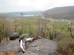
The climbing starts right away up a rock face in Suffern. In the photo to the left, you can see the town of Suffern behind us. From there, the hike rolls up and down hills of varying size.
I started off trying to keep pace with a few people - near the back, mind you; I wasn't trying for any record - which turned out to be a mistake, as I was walking faster than was comfortable and burned myself out a bit. I finally slowed down some, but even so was going faster than I could enjoy. At the bail-out point, 13 miles in, I did think about bailing out.
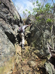 Instead, I went on, and the hills continued, up to the Irish Potato and then up Pyngyp (pictured). Frankly, I found scrambling a nice change from walking uphill.
A few miles from the end, we caught up with a few Ramblers who had started out an hour early. I slowed down with them, and was finally going at a pace I found comfortable. (Endurance I have ... speed not so much.) We weren't quite the last ones done, but almost.
I don't think I'd do it again - once was plenty. Nevertheless, completing it gave me a nice sense of accomplishment.
No comments:
Post a Comment