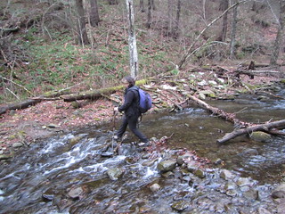
 Since our first attempt to hike Eagle had been stymied by a deep stream crossing, we decided to try again. The Rider Hollow route, the shortest, was out, as the water would still be high. The Seager Road route is by far the longest, and it has several stream crossings. That left McKenley* Hollow, with a couple of easier stream crossings, a medium length - and a lot of elevation gain, about 1,000 feet more than Rider Hollow.
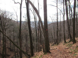
The warm weather meant that the lower slopes were almost totally bare of snow. It was well above freezing, so what was left continued to melt. We started off with bare boots, with no need for any kind of traction devices.
The 1.9 miles up the Oliverea-Mapledale trail to the junction with the Pine Hill-West Branch trail comprise the toughest part of this hike. It’s quite a steep slope as you follow the creek. Fortunately, the trail moderates at a little over 3,000 feet at the col between Eagle and Balsam Mountains.
 There, we put on our microspikes for the final 2.1 miles, since there were icy rocks and slushy snow. The trails follows a long ridge before heading up for a final climb to Eagle’s 3,600-foot summit. We were worried about time, and I was afraid we might have to turn around to avoid hiking in the dark. Fortunately, we met a group of hikers returning from the summit with a GPS, and they told us it was .75 miles to the top. We didn’t necessarily enjoy the last climb, but we made it.
Eagle’s summit doesn’t have a view. The summit itself is off the trail, although canister-less, and marked by a cairn. To get any views at all on this route, I recommend hiking when the leaves are off the trees; you’ll get glimpses of some mountains as you go.
With Eagle down, I have only one peak left to complete my Catskills 3500. SW Hunter, here I come.
*The map shows it as McKinley, but the signs say McKenley. I’m not sure which is right.
No comments:
Post a Comment