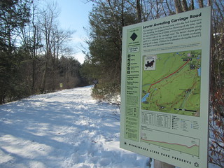
 After a tough hike on Saturday, I backed out of the Catskills hike I was going to do on Sunday. Instead, I went to Minnewaska, figuring I could find something easier and beautiful. This winter, parking for hikers/snowshoers is limited to two lots, so I parked at the Lower Awosting lot and somewhat randomly decided to aim for Rainbow Falls. I didn't have my nice maps with me, so I downloaded the official park map to Avenza and set out.
I'm pausing the narrative here to state that the official park map is very bad. It uses bubbly dotted lines for some trails, which caused me confusion a couple of times; one time it looked like the trail crossed a creek (it didn't) and another time I had to look about five times to see if two trails intersected (they didn't). Also, the contour lines aren't at sensible levels. Moreover, it doesn't use visual clues to give some information more weight than others. Every item on it is competing for the user's attention. I just want to get this off my chest - not that it is crucial to the story.
Skipping the snowshoes in favor of microspikes, I headed down the Mossy Glen trail before joining the Lower Awosting Carriage Road. According the the NY/NJ Trail Conference maps, "some" carriage roads are groomed and closed to hikers in the winter; it's worth noting that there was no more specific information available at the entrance or at the maps posted at many junctions. In any case, this particular carriage road was open.
From there I turned onto Jenny Lane (after first going the wrong direction), then onto the Rainbow Falls trail. Foot traffic fell off here; I was following a couple sets of footprints rather than a packed track. The trail also started to get hillier. Traffic really fell off once I came to a creek crossing. Water must have been higher than usual; there was a way across, but clearly not the usual one. It was evident some hikers had turned back here, and from here on I was following the prints of only one person and a dog.
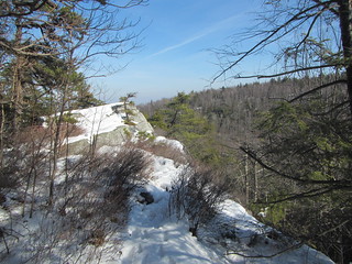 The trail climbed a ridge to follow along a cliff. In summer, there are no doubt some beautiful views from the edge, but I wouldn't try it in winter. The snow was melting in the 40° and sunny weather, making for some slippery trails.
The trail then climbed down a cliff and through a bit of forest to reach Rainbow Falls itself, which was quite spectacular. After pausing to enjoy it, I continued on the trail, which climbed to reach another carriage road, which was when I had a problem: This carriage road was groomed for skiers only. Sure, the Rainbow Trail kept going, but it would soon dead-end at another (presumably) groomed carriage road.
My choices were (a) go back, including a very slippery climb up a cliff, on a path no one else was using, (b) bushwhack through the snowy woods to reach the Blueberry Run hiking trail, or (c) walk on the ski trail.
In retrospect, bushwhacking likely would have likely worked, since it would have been a short shot, but this is one place where I was struggling with the map. Retracing seemed unsafe. So, I am sorry, dear skiers, but I walked on your trail. On the far edge, where one other person had already walked, where only the tippytoes of skis has reached, but nevertheless on your trail. I really am sorry for any inconvenience I caused. (And NY State Parks, you know where to fine me.) But really, I do think it was unnecessary for me to be in that situation; there's no reason park maps or flyers couldn't inform hikers in advance of which carriage roads are closed to them.
As soon as I reached the Blueberry Run trail, I took it until it intersected with the Mossy Glen trail, which I followed back to the car, feeling slightly guilty the whole way. I didn't track the hike, but it was about six miles. And now, here is the moment you have been waiting for: Rainbow Falls.

No comments:
Post a Comment